By 3/31/23, US Army Corps HATS flood plan needs to hear from you

Updates since close of comment period

11/15/23 press release from officeof Congressman Dan Goldman:

In short: the NYS Department of Environmental Conservation (DEC) invoked the agency’s role as formal non-federal sponsor of HATS. NYS DEC’s letter to USACE triggers a federal requirement that HATS include comprehensive flood protection (not just protection for storm surge/harbor seawater overriding the shoreline.)

STATEMENT FROM CONGRESSMAN DAN GOLDMAN ON NEW YORK STATE REQUIREMENTS FOR COMPREHENSIVE APPROACH TO US ARMY CORPS OF ENGINEERS FLOOD PROTECTION PLAN   

Washington, D.C. – Congressman Dan Goldman (NY-10) today issued the following statement after the New York State Department of Environmental Conservation (NYSDEC) sent a letter requiring the US Army Corps of Engineers (USACE) to revise their $52.6 billion New York and New Jersey Harbor and Tributaries Study (HATS) storm surge protection plan to include a comprehensive approach to address a multitude of flooding risks. This announcement comes after Congressman Dan Goldman and Congresswoman Nydia Velázquez led twelve Members of Congress from New York and New Jersey in sending a bipartisan letter to the USACE expressing concern that the Corps plan to address flood risk insufficiently protects New York and New Jersey against multiple varieties of flooding.   

“I am thrilled that the New York State DEC formally requested that USACE revise their flood protection plan to include a comprehensive approach to flood risks across the New York and New Jersey harbor and tributaries.   

“While the initial proposal failed to sufficiently address the flooding risks faced by our communities, I am encouraged at the hope for a revised plan that will protect New York and New Jersey’s coastal communities.   

“Our states face a multitude of flooding risks, including not only storm surge but tidal and river flooding, heavy rainfall, groundwater emergence, erosion, and sea level rise. To ignore these flooding threats that endanger our region would be an irresponsible use of taxpayer dollars.  

“I am pleased to see that the New York State DEC has heeded the calls to ensure our communities receive comprehensive flood protection in accordance with federal laws. With this important letter from DEC, I expect USACE to promptly issue comprehensive implementation guidance and not delay compliance with the Water Resources Development Acts any longer. This must include a period of public review and comment to ensure that this revised plan adequately addresses community concerns.  

“Disadvantaged communities across our region must receive proper protection from all forms of flooding, and they must be included in reviewing and considering these plans. I look forward to working with all stakeholders to ensure that the new plan is comprehensive and has the best interest of New Yorkers at its core.” 

9/13/23 excerpt from press release from office of Congressman Dan Goldman:

CONGRESSMAN DAN GOLDMAN AND CONGRESSWOMAN NYDIA VELÁZQUEZ LEAD MEMBERS OF CONGRESS IN DEMANDING COMPREHENSIVE FLOOD PROTECTION FOR NEW YORK AND NEW JERSEY  

Upcoming U.S. Army Corps of Engineers Flood Protection Plan Only Protects Against Storm Surge, Neglects Tidal and River Flooding, Heavy Rainfall, Erosion, and Sea Level Rise Threats  

Members Urging U.S. Army Corps of Engineers to Update Protection Plan, Bring into Compliance with Water Resources Development Act and Justice40 Initiative  

Read the Letter Here 

Brooklyn, NY – Congressman Dan Goldman (NY-10) and Congresswoman Nydia M. Velázquez (NY-13) today led twelve Members of Congress from New York and New Jersey in sending a bi-partisan letter to the United States Army Corps of Engineers (USACE) expressing concern that the Corps plan to address flood risk insufficiently protects New York and New Jersey against multiple varieties of flooding. The upcoming plan fails to address tidal and river flooding, heavy rainfall, groundwater emergence, erosion, and sea level rise. Their plan also does not comply with the Water Resources Development Acts (WRDA) of 2020 and 2022 or President Biden’s Justice40 Initiative (J40).  

“With the passage of WRDA, Congress directed the Army Corps to formulate a plan that protects the region from tidal and river flooding, heavy rainfall, groundwater emergence, erosion, sea level rise and storm surge,” wrote the Lawmakers. “However, after seven years of planning, the Army Corps is proposing to spend $52.6 billion to protect our constituents from only one kind of flooding - storm surge. Members of Congress worked diligently to pass WRDA on behalf of our constituents in communities that remain vulnerable to multiple flood threats, and we urge HATS to comply. To ignore the more frequent flooding threats that plague our region is an irresponsible use of taxpayer dollars.”  

In the letter, the Members list actions that they would like USACE to take to better protect millions of residents in the New York-New Jersey metropolitan area from flooding:    

  1. Promptly issue implementation guidance on applicable directives in 2020 and 2022 WRDA legislation; 

  2. Factor that guidance into the current draft environmental impact study (DEIS) to conduct additional analyses and develop additional alternatives; 

  3. Ensure that disadvantaged communities are properly protected; and 

  4. Issue a Supplemental Draft Environmental Impact Statement (DEIS) for public review and comment before reaching the Agency Decision Milestone.  

The New York-New Jersey Harbor and Tributaries Focus Area Feasibility Study (HATS), and its upcoming Agency Decision Milestone (ADM), tentatively scheduled for release this summer, does not comply with the Water Resources Development Acts (WRDA) of 2020 and 2022 or President Biden’s Justice40 Initiative (J40).  

In addition to Velázquez and Goldman, this letter was signed by Representatives Yvette Clarke (NY-09), Adriano Espaillat (NY-13), Hakeem Jefferies (NY-08), Michael Lawler (NY-17), Greogory Meeks (NY-05), Grace Meng (NY-06), Jerrold Nadler (NY-12), Alexandria Ocasio-Cortez (NY-14), Donald Payne (NJ-10), Patrick Ryan (NY-18), Paul Tonko (NY-20), and Ritchie Torres (NY-15).  

The comment period closed. Below is our work until that deadline

PortSide’s comment is here. We continued working on this after posting a draft comment here on 3/29.

The deadline for comments is 3/31/23. If you don’t speak up, you can’t be heard! Please submit comments. See the tips for making comments below. You don’t need to be an expert. Express concerns if you have them, suggestions if you have them.

PortSide Zoom - learn more about alternatives to USACE HATS plan:

Don’t like The Big Grey Wall proposed by USACE HATS?
Learn about alternatives!
The recording, chat and transcription for the Zoom on 3/20/23 are in Dropbox at the same link used to register
www.bit.ly/ALTresiliency. Download the one-page PDF in there; it’s a handy intro to all this.

  • Presentation by Belgian firm Aggeres of their surge-powered flood barriers (SCFB)

  • Presentation of landscape architecture resiliency by Walter Meyer and Tom Asbery from LOCAL

  • Screening 9-minute segment of this TEDx presentation about “Red Hook Island” – a barrier island proposal by Red Hook resident Alex Washburn

3/7/23 BREAKING NEWS! The deadline for comments has been extended to 3/31/23.

The USACE presented at a Zoom Town Hall, Monday 3/6/23, 7pm hosted by Congressman Dan Goldman and Brooklyn Community Board 6.

  • Recording and presentation and Zoom chat are here.

  • Issues we raised at that Town Hall are here. We have yet to write a final comment.

  • Brooklyn Paper article about that Town Hall is here.

Thanks to CB6 and Congressman Dan Goldman for hosting this Town Hall. Thanks to Congressmembers Dan Goldman and Nydia Velazquez for getting the Army Corps to do this - finally - and for getting the extension of the comment deadline.

March 31, 2023 is the newly extended deadline for comments on a MASSIVE $52 billion plan for flood protection by the US Army Corps of Engineers (USACE) called HATS, short for Harbor and Tributaries Focus Area Feasibility Study. 

The catch? The thing is 569 pages long, and it’s webpage has additional documents, videos, and interactive pages! In total, it is 4,000 pages.
Send comments to nynjharbor.tribstudy@usace.army.mil
The website is here.
The 569 page plan is here.
What they call the Readers Guide is contents, a description of which document (website link) contains what. Since some of those links have no description in the name, this is key to finding stuff.
The interactive NYNJHAT Study StoryMap is here.
Their glossary of acronyms is here.
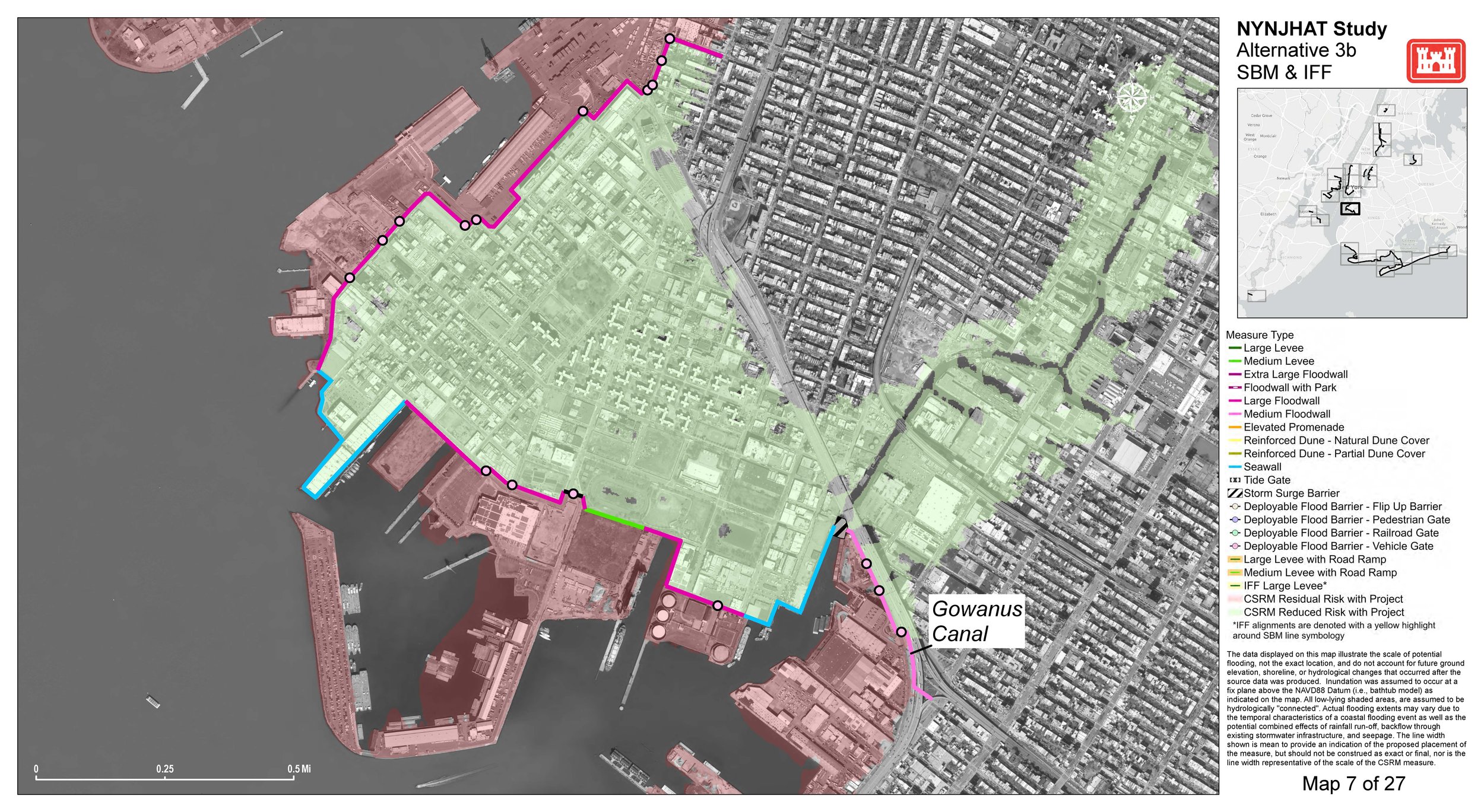
Pg 7 of Sub-appendix B1: Shore-Based Measures  has a map showing the different kind of structures “measures” proposed to protect Red Hook and their locations.

  • Mr. Bryce W. Wisemiller
    Project Manager
    U.S. Army Corps of Engineers New York District
    Jacob K. Javits Federal Building, Room 17-401
    c/o PSC Mail Center
    26 Federal Plaza
    New York, NY 10278
    917-790-8307
    nynjharbor.tribstudy@usace.army.mil

    Ms. Cheryl R. Alkemeyer
    NEPA Lead
    U.S. Army Corps of Engineers New York District
    Jacob K. Javits Federal Building, Room 17-420
    c/o PSC Mail Center
    26 Federal Plaza
    New York, ny 10278
    917-790-8723 nynjharbor.tribstudy@usace.army.mil

  • See the guide here.

At right, that big grey wall is what they are proposing for much of Red Hook. A flood gate would go at the mouth of the Gowanus Canal.

This “Floodwall Concept for Coffey Street and Ferris Street” shows they need to make a 25’ wide trench and have to drive piles 75’ deep to support these walls. Red Hook buildings have cracked during recent pile driving for new construction. These flood barriers look to involve driving a LOT of steel H-piles. Would vibrations from installing piles this deep damage buildings? One negative impact looks certain, such a deep, wide, long installation along Beard Street would cause traffic gridlock in Red Hook due to how it would likely reroute and delay the last mile trucks using the two Amazon facilities on Beard Street, plus IKEA shoppers.

For years, PortSide has asked if surge-powered flood barriers such as the Aggeres SCFB in the video below could work in NYC. In the video, incoming flood waters push the flood barrier up! We’d like the SCFB and other non-permanent barriers assessed, so we had Aggeres present during our 3/20/23 Zoom, linked above.

A 2/22/23 email from Aggeres says “We engineered the SCFB barrier up to 3m high (which is feasible). In theory the barrier could even be higher, but then many other factors must be taken into account (foundation, very large concrete basins, etc). We have installed barriers up to 2m protection height.” Here is an engineering animation of how the SCFB works.

The plan the USACE has tentatively selected, called Alternative 3B, proposes a 14-year construction project with 12 storm surge gates around waterways of the NYC region such as the Gowanus Canal, Newtown Creek and near the Verrazano Bridge). It would also create barriers along 41+ miles of NYC’s shoreline, including seawalls and floodwalls in Red Hook and elsewhere in south Brooklyn, Lower Manhattan, East Harlem, and all of the Rockaway Peninsula 

You can see 3B, the Tentatively Selected Plan (TSP), running through Red Hook below. This is from Pg 7 of Sub-appendix B1: Shore-Based Measures. The circles in the colored lines are the only places they have planned an opening in the barrier wall.

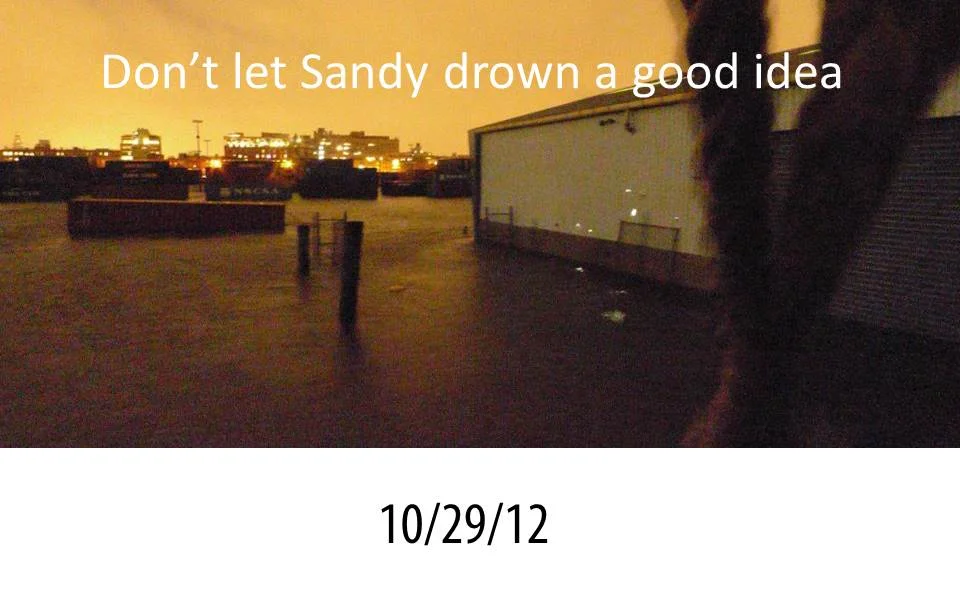
PortSide has focused on resiliency topics for the decade since Sandy; but we do NOT have time right now to digest and summarize 569 pages for you – we have to deal with our campaign #rethinkEDC, and work on our own Sandy recovery since FEMA gave us a deadline of 7/31/23 to finish the project. So… here’s what we’re offering you:

1.       Honesty about our limitations on this as per above.

2.       The info bove and below. Request for comments to the blogpost that we can incorporate to improve this resource.

  • We did word searches. Red Hook is mentioned 18 times. Sunset Park, our neighbors across Gowanus Bay and part of our City Council district D38, only got mentioned 2 times (both about rail yards). Gowanus is mentioned 25 times. See page 13.

    NYCHA is mentioned only once ☹ and for something in Manhattan.

    Page 6 is overview map of the whole thing.

    Page 8 Project Cost includes item Cultural Resource Preservation.

    Page 220 shows RH map and barrier locations.

    Here’s a one pager showing a Red Hook flood wall section at Ferris and Coffey Street next to Valentino Park.

    Pg 160 summary of Red Hook’s resiliency projects – this does not mention the HUGE resiliency project underway to protect the NYCHA properties (Red Hook Houses East and Red Hook Houses West)

    “Red Hook, Brooklyn, NY The City of New York is expected to complete the design phase of the Red Hook Coastal Resiliency Project (RHCR) by the end of 2022. RHCR is an integrated coastal protection system for more frequent, lower intensity coastal storm surges and tidal flooding. Community engagement is a key component for project development since the earliest stages of project feasibility. The project has also aimed to maintain access to the waterfront, and create improved public spaces in response to six years of community engagement. The Red Hook Coastal Resiliency Project will be a critical step toward ensuring a more resilient Red Hook community in the face of future extreme weather and a changing climate.”

    Pg 219 “The Gowanus Canal storm surge barrier would provide coastal storm risk management in the neighborhoods of Gowanus, Red Hook, and Park Slope, Brooklyn (Figure 49). The storm surge barrier would include a navigable miter gate. It would span approximately 200 feet from shore to shore and would have one gated navigable passage 100 feet wide, with a sill elevation at -21 feet NAVD88. The proposed structure crest elevation is +16 feet NAVD88. On the east side of the storm surge barrier, shore-based measures such as deployable flood barriers and floodwalls tie into higher ground. On the west side of this storm surge barrier, shore-based measures are proposed to provide flood risk reduction for the Red Hook neighborhood and are placed in proximity to, or at the coastal edge. These shore-based measures may potentially include seawalls, levees, floodwalls, and deployable flood barriers.”

    Pg 248 & 241 show that one concern/motive of theirs is to keep water from getting in the Battery Tunnel and BQE trench near here: “major vehicular tunnels in the Study Area would also be increasingly exposed to coastal flood risk in the future without-project condition”

    under Surface Roads “For example, the proposed alignment of shore-based measures in the Red Hook neighborhood in Brooklyn includes several vehicular gates that, when deployed, would block vehicular, bicycle, and pedestrian traffic.”

    Pg 482 Summary of Construction Footprint and Operations and Maintenance Impacts Associated with the TSP (Alternative 3B) on Roads, Bridges, and Tunnels. For example, the proposed alignment of shore-based measures in the Red Hook neighborhood in Brooklyn includes several vehicular gates that, when deployed, would block vehicular, bicycle, and pedestrian traffic.

    Pg 520 Impacts Associated with the Alternative 3B on Schools “There are four public schools in the storm surge barrier managed risk area of Red Hook, Brooklyn.” Do public schools only count?! How about the 3 other schools (2 charter, 1 private), and we count 3 public schools not 4.

    Pg 524 Summary of Historic Properties. We note that the list does NOT include a category for National Register ships! Red Hook has two, our MARY A. WHALEN and the LEHIGH VALLEY 79 of the Waterfront Museum. We note low income communities like ours DO have historic properties but that listing them doesn’t happen much in our kinds of neighborhoods, plus the local NYC preservation process, the Landmarks Preservation Commission (LPC), has NOT been receptive to Red Hook efforts to landmark buildings (Todd Pump House, Todd Graving Dock, Bowne Storehouse, Lidgerwood), and many historic structures were leveled to make space for last mile centers. However, we do still have historic properties listed (the Parks Rec Center) and unlisted (brick and stone warehouses by the water in particular). In short, privileged communities get preservation; low-income communities of color don’t. Does the Justice40 Initiative of the White House come into play here?

  • Monday 3/6/23, 7pm, at a meeting co-hosted by CB6 and Congressman Dan Goldman’s office, the Army Corps (USACE) presented at a Zoom Town Hall

    • Recording and presentation and Zoom chat are here.

    • Issues PortSide raised at that Town Hall are here. We have yet to write a final comment.

    • Brooklyn Paper article about that Town Hall is here.

    Rebuild by Design has a webpage with 8 videos

    1 hour and 15 minutes webinar recorded February 22, 2023 with Gowanus Canal Conservancy on the panel along with Hudson Riverkeeper, Newtown Creek Alliance, Baykeeper, Miami Waterkeeper

  • See PortSide’s history in Red Hook WaterStories here.

  • See the USACE one-pager on their EJ position and Justice40 here.

    It says “If there is a localized concern regarding the plan that might impact a disadvantaged portion of your community, we want to know! Comments Please!

    Send comments with subject line EJ to nynjharbor.tribstudy@usace.army.mil

  • There is opposition to HATS from environmental groups. We share this Gothamist article without endorsement (as we said up top, we have not had time to drill down on this).

Help make Red Hook more resilient on Thurs 3/17

Front of resiliency postcard

front of resiiency postcard portside will be distributing during 2022. back of postcard is at bottom of blogpost

Dear Red Hook friends,

PortSide has an opportunity to work with a group of visiting High School students who will distribute poscards with flood prep info arojund Red Hook on Thursday morning March 17.  There is a Facebook event at https://fb.me/e/4tr9QIRPi you can share.

We are especially interested in getting High School students involved so that they get a cultural exchange experience of working with the visitors while helping those visitors understand Red Hook and find their way around.

Would you like to get involved? If so, please RSVP asap to chiclet@portsidenewyork.org. Please share this blogpost!

Thursday, 3/17 Schedule

9:30 am         45 minutes orientation presentation about Red Hook’s Sandy story with time for QnA.
10:15 am       15 minute break and time to get postcards, Red Hook maps and clipboards to students
10:30 am       Head out to distribute postcards and do some surveys
12:00 pm       Debriefing session, recording a video of student impressions and feedback
1:00 pm         Lunch

1-3 and 5 take place in the office suite at the SE corner of the Pier 11 warehouse. That is between our ship MARY A. WHALEN and Pioneer Street. Thanks to Formula E for the use of this office space.

 We seek people for the following roles:

  • A Red Hook business owner who was here during Sandy.

  • More People to accompany the visiting students as they distribute postcards (see photos top and bottom)

Program and backstory.

PortSide was approached by CAStrips, an international organization that organizes school field trips. They are bringing 30 students from the Houston International School Awty to NYC to do community service and learn about infrastructure. 

Since 2022, is the 10th anniversary of Sandy and we saw during hurricanes Henri and Ida last fall that Red Hook people could use info on flood prep, we proposed that the Awty students kick off PortSide’s 2022 outreach about flood prep. 

PortSide is creating a postcard in English, Spanish, and Chinese to hand out around Red Hook, directing people to info we offer at https://redhookwaterstories.org/tours/show/9. The 3/17 distribution event will only reach part of Red Hook; we will focus on stores on this one. 

If you can’t get involved with this event, we hope you will join a future one. CAStrips wants to send more students in May, and we hope to have all-Red Hook groups do distribution too.

Overview of the orientation speakers and content:

  • PortSide

  • NYCHA residents here during Sandy - Karen Blondel and Vanessa McKnight are speaking

  • Medical Matt (Matt Kraushar, MD PhD) who set up medical response corps after Sandy, mostly serving NYCHA residents. He will participate from Germany via Zoom.

  • Jim McMahan “Map Man” who made Red Hook’s Sandy flood map will be represented by this video

  • Red Hook business owner who was here during Sandy, if we get one

PortSide will talk about our experience protecting our ship from hurricane Sandy, what we learned about Red Hook damages while running our Sandy recovery center and then a virtual one and while appointed to NY Rising; resiliency planning we have done and that NYC government has planned and/or executed through the years since Sandy (some of it you can see within yards of our ship).  We will refer to City-executed resiliency plans for Red Hook on this webpage. We will refer to Resiliency 101 info in our virtual museum. PortSide has a FEMA Sandy recovery project, so we can speak as a storm victim too. 

Image below is the back of the postcard that will be handed out during this event, and over 2022. The front of the postcard is at top.

back of resiiency postcard portside will be distributing during 2022. frontof postcard is at top of blogpost

Unveiling of Atlantic Basin Sandy High Water Mark sign & Red Hook Sandy Flood Map

Camille Casaretti, President of the Community Education Council 15 (CEC15), stopped by to see how the sign and map could be used for educating school groups. She was greeted by PortSide Executive Director Carolina Salguero dressed as Bio Luminesence…

Camille Casaretti, President of the Community Education Council 15 (CEC15), stopped by to see how the sign and map could be used for educating school groups. She was greeted by PortSide Executive Director Carolina Salguero dressed as Bio Luminesence and PortSide Historian and Curator Peter Rothenberg.

On the 7th anniversary of hurricane Sandy, October 29, 2019, PortSide NewYork unveiled a Sandy High Water Mark sign at the pedestrian entrance to Atlantic Basin/NYC Ferry/Brooklyn Cruise Terminal in Red Hook, Brooklyn.

PortSide’s role in the creation of the Sandy High Water Mark FEMA/OEM program

Creating Sandy high water mark signs was a PortSide proposal at the White House event where we received our Champions of Change award for Sandy work. The structure of the award event was to put all the honorees on a panel and pepper us with questions to harvest ideas. The senior Federal Disaster Recovery team sought a follow-up with PortSide and come to meet us for many hours aboard the MARY WHALEN. According to Ken Curtin, the Federal Disaster Recovery Coordinator FEMA for Sandy in NY (see his video below), PortSide was the first to propose such a sign program. FEMA executed the idea and created the Sandy High Water Mark program, and NYC Emergency Management is now involved in the program.

PortSide also unveiled a banner with a map of Red Hook Sandy flooding made by a local cartographer Jim McMahon. See a copy in our e-museum here.

Carolina Salguero, Executive Director of PortSide NewYork, articulating the message from Bio Luminescence, a costume worn for Red Hook Barnacle Parade, commemorating Sandy, as well as the unveiling of a sign marking Sandy’s high watermark. The parade followed shortly after.

Assistant Commissioner Christina Farrell, NYC Emergency Management speaks. October 29, 2019.

Ken Curtin, recently retired FEMA Federal Disaster Recovery Coordinator speaking. He explained the backstory that led to the creation of the program that makes these signs, citing PortSide’s role in that story.

Carolina Salguero, Executive Director of PortSide NewYork (and Bio Luminescence for Red Hook's commemorative Barnacle Parade), speaks. October 29, 2019

PortSide NewYork's unveils a sign marking the high watermark at Red Hook's Atlantic Basin during hurricane Sandy on its seventh anniversary. Natasha Campbell, Founder of Summit Academy and PortSide NewYork board member, speaks. October 29, 2019

Unveiling the Sandy High Water Mark sign and a Sandy hurricane flood map of Red Hook by cartographer by Jim McMahon.

Dan Wiley, Congresswoman Nydia M. Velázquez's District Director of Southwest Brooklyn, speaks. October 29, 2019


Copied below

Press Release Unveiling of Atlantic Basin Sandy High Water Mark sign Red Hook Sandy Flood Map


Tues 10/29, 3:15-3:45pm

Unveiling of Atlantic Basin Sandy High Water Mark sign Red Hook Sandy Flood Map

Pedestrian gate to Atlantic Basin/NYC Ferry/Brooklyn Cruise Terminal
West end of Pioneer Street at Conover Street, Red Hook, Brooklyn, NY 11231

Followed by 4pm Barnacle Parade which musters at Pioneer and Van Brunt, one block away. 

On the 7th anniversary of hurricane Sandy, October 29, 2019, the nonprofit PortSide NewYork will unveil a Sandy High Water Mark sign at the pedestrian entrance to Atlantic Basin/NYC Ferry/Brooklyn Cruise Terminal in Red Hook, Brooklyn. This sign is an official program of FEMA and NYC Emergency Management.  Sandy’s surge was 5.75 feet high at this location. 

PortSide will also unveil a banner with a map of Red Hook Sandy flooding made by a local cartographer Jim McMahon. See a copy in our e-museum at https://redhookwaterstories.org/items/show/919.  

Immediately after the unveiling, joins us in Red Hook’s Barnacle Parade that kicks off at 4:00pm half a block up Pioneer Street and proceeds to pass the new signs. This parade is the way Red Hook memorializes Sandy since 2013 on the “Sandyversary” of 10/29.  

Carolina Salguero, Founder and Executive Director of PortSide says “After riding out hurricane Sandy on our ship to protect her from the storm, I and our Historian/Curator Peter Rothenberg came ashore to Red Hook. I was heartbroken to find the condition of our community.  I told the PortSide crew that we’re going to try and help. Our first move was to set up a pop-up aid station at Realty Collective which we ran the month of October.  PortSide has worked since that time, in many ways, to help Red Hook recover and become more resilient and to help foster resiliency for New York as a whole. Understanding the potential of our waterways is the crux of PortSide’s mission, and Sandy amplified our mission to include understanding marine weather and the destructive potential of water.  This year, PortSide’s resiliency work includes the installation of this Sandy High Water Mark sign, and next to it, the Red Hook Sandy flood map created by Jim McMahon that shows where Sandy flooded Red Hook and land elevation around our beloved but vulnerable peninsula. I hope that these signs will help educate students and adults and help them prepare for future floods.”  

The unveiling of these signs sign is another phase in PortSide’s recovery and resiliency planning work since hurricane Sandy.  PortSide received a “Champions of Change” award from the Obama White House for Sandy prevention work (protection the MARY A. WHALEN) and Sandy recovery work for Red Hook.

https://obamawhitehouse.archives.gov/champions/hurricane-sandy/carolina-salguero-(portside-newyork)

 The New York State Senate also honored PortSide for their Sandy recovery work.

https://www.nysenate.gov/legislation/resolutions/2013/j2531

PortSide founder Carolina Salguero was appointed by the Governor’s office to the NY Rising committee (the precursor to Resilient Red Hook) that created a resiliency plan for Red Hook.  For further information about Sandy and resiliency planning, visit PortSide’s e-museum Red Hook WaterStories (RHWS) www.redhookwaterstories.org  

Rep. Nydia M. Velázquez (D-NY):

“Today, seven years to the day Superstorm Sandy hit, we remember the damage our entire community endured and how we came together to help one another. This high-water mark sign sends a message that we must all continue to build community resiliency and fight climate change. I would also like to recognize PortSide NewYork’s role in Sandy recovery for which it received the White House ‘Champions of Change’ award in 2013. PortSide dreamed up a project like High Water Mark Initiative which FEMA created and NYC Emergency Management has been implementing here and around the city. This program helps alert residents and visitors alike to the dangers of storm surge and the need to be ready with a plan for the next storm. For my part, I will keep working with officials at all levels of government to promote Red Hook and our City’s resiliency and sustainability.”

New York State Senator Velmanette Montgomery says, "The Barnacle Parade represents the strength of Red Hook in the wake of super storm Sandy and serves as a reminder to all of us how climate change impacts our communities more and more each year. I am proud to represent Red Hook residents and organizations like PortSide New York who took this as a call to action and have been working tirelessly to build a more resilient community."

Councilman Carlos Menchaca says, "Red Hook’s water mark sign is a reminder of our community's resilience and how much more is needed to prepare for the next storm. The symbolic gesture must force us all to take seriously the urgency of this moment, and to do everything in our power to protect our most vulnerable neighbors from the worst effects of climate change. Thankfully, we have organizations like PortSide New York to keep us laser focused on this threat while celebrating what we've accomplished."

NYC Emergency Management Commissioner Deanne Criswell: “This High Water Mark sign is a reminder of the life-threatening risks associated with storm surge. It also highlights the strength of the Red Hook community, and serves to educate individuals about the importance of preparing for a coastal storm,” said NYC Emergency Management Commissioner Deanne Criswell.  “Through this and other initiatives, we remain dedicated to working closely with community leaders to build a culture of preparedness through stronger, more resilient neighborhoods.”

Ken Curtin, formerly of FEMA says “I was the FEMA Federal Disaster Recovery Coordinator for Sandy in NY. We came to meet the PortSide team in Red Hook since we were impressed with the recovery and resiliency ideas that they shared at the White House ceremony where they won a Sandy recovery award. Their ideas were practical, actionable and common sense, except that common sense is not so common any more. PortSide proposed that signs be installed to mark Sandy flood levels to help communities prepare for future floods. I’m glad that this program was implemented by FEMA and then adopted by NYC Emergency Management.”  

Gita Nandan, co-chair of Resilient Red Hook says, “We are thrilled about the installation of the high water mark sign. Having a physical marker in remembrance of Super Storm Sandy helps keep the memory alive of this turning point in Red Hook. As a waterfront community, Red Hook is on the forefront of climate change, and this will help keep us activated to ensure we build a resilient community for future generations.”  Resilient Red Hook is made up of concerned residents working together to steer the future of Red Hook. More at https://www.resilientredhook.org/ 

Michael Racioppo, District Manager, Brooklyn Community Board 6 says, “The high water mark high of Superstorm Sandy is something that should remind us throughout the year, not just during Halloween week, how scary the impact of climate change is.  Reminding us to be vigilant in order to maintain great waterfront, and great waterfront neighborhoods, is the continuation of the work PortSide does.”  

About PortSide NewYork www.portsidenewyork.org & www.redhookwaterstories.org
PortSide is a living lab for better urban waterways. PortSide connects New Yorkers to the benefits of our waterways and ports.  PortSide produces WaterStories programs on and off the historic ship MARY A. WHALEN in education, culture, resiliency and job training.


# # #


REPOSTING: PortSide NewYork Sandy Story Part 1: saving MARY WHALEN

10/27/19 We are reposting this 2013 blogpost to foster flood preparation. The post describes four days of preparing for Sandy. Today’s gale and the approaching date of 10/29 is reminding us of Sandy - and we want you to know about PortSide’s event on 10/29/19 at 3:15pm, the unveiling of a Sandy High Water Mark sign at the pedestrian entrance to Atlantic Basin, Red Hook, Brooklyn, corner of Pioneer and Conover Streets. At 4pm, the Barnacle Parade kicks off up the block. The parade is the way Red Hook commemorates Sandy since the one-year anniversary of the devastating storm.

This is PortSide NewYork's hurricane Sandy story, installment one.  

Installment one is a personal report by Carolina Salguero, Director of PortSide, speaking as Shipkeeper of the MARY A. WHALEN.  This installment covers PortSide's time in port preparing for Sandy, riding out the storm on the tanker, assessing our damage. We think the ship-related segment of our Sandy story is important because it shows how the maritime community in the port of NY-NJ spent days preparing for Sandy.   The maritime community has something to offer inland neighbors in terms of understanding how to assess flood risks and prepare for them.

The second installment of our Sandy story will cover PortSide's effort to help inland Red Hook, Brooklyn recover from the storm. 

The third installment will cover lessons learned and ideas for the future.

What a difference four days can make

Thursday, 10/25/12, Sandy minus four, the PortSide crew is excited to be hosting an elementary school class aboard the tanker MARY A. WHALEN.  After finishing a TankerTour and jolly lunch for 30 on deck with the City + Country School and waving goodbye to their coach bus, Dan Goncharoff says “have you been looking at this storm coming up the coast?”

C + C School visit, Thursday morning

I check the weather websites. This looks like hurricane Irene plus some.  

We convene a crew meeting and start hurricane preparations. School docents become a Sandy prep squad. By end of day, the deck was cleared of anything that could blow, and I am calling and emailing around for crew to help prepare and to ride out the storm on the ship. 

Friday morning, after more info about the storm, I am trying to find a protected berth for the tanker MARY A. WHALEN.  Just days before, we received word that our application had been accepted; the ship was on the National Register of Historic Places! Since the MARY is not fully restored, she lacks some equipment that would help her in a big storm: a working engine (eg, the ability to run away), machinery to raise her anchors if dropped to hold us in place, and a winch to haul in docklines under load. Compensating for that involves some extra forethought. 

Despite our efforts, we can’t find a good alternate berth for the MARY outside of the Red Hook Container Terminal.  Hughes Marine says “We’re out of space. You’ll be able to walk across Erie Basin by the time this is over; it will be so full of vessels.”  A contact at a shipyard says “we flooded during Irene, and this one looks to be worse, you sure you want to be over here?” “No and good luck,” is my answer.

After more checking of the weather, I decide to move the MARY where she rode out Irene, on the other side, the north side, of our current Pier 9B. (The south side lines up with the end of Degraw Street). For non-sailors, here’s how this kind of calculation goes:

Winds were expected to start from NE, swing around to the East and end up SW, but this could always change. If rough weather were coming from anything west to southwest, our current position has us exposed to the wind from the southwest and the fetch (long stretch of water over which wind can build up waves) from Staten Island up the Buttermilk Channel

The fendering (the wooden cribbing protecting ship and pier) is not robust on this side. A big advantage to the north side are some pilings at the inshore end that stand much taller than the pier and which would help prevent the tanker from riding up onto the pier if the surge were really high. 

The north side would have us more exposed from winds at the start of the storm, but the hill of Brooklyn Heights and the pier to the north of us (even though it has no shed) would provide a compensating wind break.  

As the wind clocked around to the south, a wall of containers near the bulkhead would provide a windbreak to the east, and the pier shed would be an enormous windbreak once the wind went south of east.  

A final consideration was that in the extreme case of docklines failing while we were on the northside, the tanker had a chance of bouncing around inside the space between the two piers for a while, maybe long enough for us to get other lines out or call for help; whereas, on the southside of the pier, if our docklines broke, tide or wind could shove the ship up on the rocks nearby to the south (surely the death of the tanker) or shoot us down the Buttermilk Channel towards unknown risks. 

I began calling tugboat companies to request a tow. Everyone is busy with storm prep so getting a tug takes a while.  I have the tug turn the MARY around so her stern faces east, putting her heavier end towards the expected wind direction. Her light bow is my worry.

The tug’s crew helps us put out storm lines, more lines than we would normally use, and double and triple parted lines. (Instead of a line just going from boat to dock, a triple-parted line goes from dock to boat to dock to boat).  The lines are set with a lot of slack to allow the boat to rise during the expected surge.  During Sandy, Peter Rothenberg and I will go out in the wind and rain to ease the lines as necessary

From Thursday until Monday, a changing array of volunteers bang through a punch list: gangway lashed to the deck. Gas generator moved near entry hatch and tested.  Gasoline, food, and water bought. Weepy portholes caulked. PortaSan moved inside the pier shed so it can't blow away.  

More calls to look for crew... Commercial boats have paid crew, but most historic vessels rely on a corps of volunteers and; with so many boats to protect, available bodies were scarce.  Compounding that, due to the dangersome spouses do not allow their partners to volunteer on the historic ships during the storm. Danger is one thing for paid crew; as a volunteer, it's another.

I ask Peter Rothenberg, our volunteer museum curator, if he wants to be crew. Peter makes a speedy calculation, “I hesitated for a moment, thinking this may be really unwise, and then said yes, probably being more reckless (brave?) than normally, because I had just lost my mother, and thus she was unable to question my judgment.”  

Peter Rothenberg

Peter Rothenberg

The harbor is abuzz with chatter on phone, email, and texts sharing weather info, plans, moral support. Mike Cohen has info on the South Street Seaport ships. Mike Abegg is dealing with the Harbor School boats. I talk to tug captains and ask Jan Andrusky, Logistics Manager of Weeks Marine, if she can share weather and Coast Guard updates as she had during Irene. Answer, “yes!” Jan is responsible for floating equipment on the eastern seaboard, the Gulf of Mexico, and more, and has lots of experience and access to weather data.

Bobby Silva, captain of a Reinauer barge up in Albany sends a text: “wish I gave you my keys to move my truck. My baby will be a goner.”  Other Reinauer crew who have not been sent out of town on vessels moved their vehicles from Erie Basin to the second floor of the garage at the Gowanus Home Depot and all their vehicles survived.

About a day before Sandy hit, the word comes that the surge would be at least 8 feet. Time to lengthen docklines.  

A sign that things will be worse than Irene is that the port moves the stack of containers along the bulkhead. My windbreak to the east is gone.  We also hear that the Port Authority will evacuate the port and lock the gates at midday before the surge, so there would be no new help getting to us. I ask the Port Authority Police officer if he will leave port if it gets really bad, “no, I will just drive a dump truck on patrol” is his stalwart answer. 

Somewhere in all this, there is an announcement that subways would stop running in advance of the storm, and Mayor Bloomberg declares evacuation for Zone A areas, which include our neighborhood of Red Hook. An evacuation order is not changing my plans, though it could limit my getting help.  

My mother calls “you’re not staying on the boat during this are you?”  My responsibility is to protect the MARY A. WHALEN and to protect her from doing damage to the property of others. AT 172’ long and 613 gross tons, she is big enough to cause a lot of destruction if she breaks loose.

Sandy is due Monday night. Sunday night, I am one of many recipients of an email telling Red Hook people which bars will be open and what movies are being screened.  This makes me wonder: Is the community ashore prepping for Sandy? Has anyone evacuated? After that email, PortSide’s maritime world feels separated from our shoreside neighbors by more than six blocks and a fence. 

Monday day, the weather rachets up.  My weather station is set up in the galley.  A laptop, a clipboard with regular print-outs of NOAA marine weather, updates from Jan, the worst news highlighted in yellow.  Peter nabs the ship's cat Chiclet and locks her in. As the weather rises, Chiclet cleans herself incessantly.  

I read the shocking news that the HMS BOUNTY has sunk in the storm, at sea. I hear from Paul Amico, a dockbuilder advising us, “I just saw a Don Jon tug heading up the North River with waves breaking over the wheelhouse.” That means 18’ waves in the Hudson.

HMS BOUNTY sinks. Photo courtesy of U.S. Coast Guard​

HMS BOUNTY sinks. Photo courtesy of U.S. Coast Guard

It gets colder and damper. I fire up the galley’s diesel stove, patented in 1918, as much to dry the air as to heat it.  As winds rise, Peter and out go out to add extra lines to the tarp covering the wheelhouse windows. After warming up over tea, I get word that the surge would be at least 12’ and would hit in about 5 hours, right at high tide. 

12’ is NOT good news. I am keen to keep the ship’s light bow from blowing or floating up onto the pier, my big worry during Irene, a risk to both boat and pier. The MARY’s stern is heavy and sits about 8’ in the water whereas her bow is actually up out of the water -- the forward engine room has been stripped, the forepeak has no ballast water, and she is carrying no cargo.  Paul Amico calls, “have you considered a preventer line?”  Yes. I turn to Peter, “time to go back out, time for a preventer line.”   

We run a line to Pier 9A, the pier 265 feet to the north of us.  We have a large collection of lightly-used docklines from tugboat friends. I bend together (that means tie together in mariner speak) two heavy eight-braid tug hawsers, and then add all our other dock lines.  To drag this through the water, we tie together an agglomeration of light line (rope) and hand-haul the collection around to the other pier.  

We are making the line off to a cleat on Pier 9A as the waters start to rise fast.  While heading back to the tanker, the waters crest the bulkhead and pool into the port.

The string piece of the pier is several feet higher than the port landmass, which gives us about 5 minutes to disconnect our shorepower cord, pull it up onto the boat, haul in the ladder, and start the generator. 

Somehow, between unplugging the shorepower from the shed and getting the cord onto the shed, our electrical system develops a short.  This means the generator turns off every time I plug in the shorepower cord. Peter then runs an extension cord to the generator to keep the laptop and mini fridge running.

So begins 35 nights, of relying on flashlights and one 15-amp extension cord, until our shorepower connection can be repaired.

The waters rise. The port’s exterior lights go out. A container lifts and bobs our way.  Humps appear in the water along the pier, like a long Loch Ness monster. I realize I am looking at all the tire fenders floating as high as their straps would allow. Somehow the overhead lights inside the shed stay on, and the windows in the doors afford the surreal view of an indoor sea.  

Peter and I watch orange bursts of light over Manhattan. “Probably transformer explosions,” I say.  Manhattan goes dark. I watch the water for several hours to make sure it isn’t rising and then sleep for several hours.

Lower Manhattan without power except at Staten Island Ferry Terminal. Jersey to the left, midtown to the right. Upsticking bolts show where head logs were ripped off the pier by Sandy.​

Lower Manhattan without power except at Staten Island Ferry Terminal. Jersey to the left, midtown to the right.
Upsticking bolts show where head logs were ripped off the pier by Sandy.

Tuesday’s plan is to shorten the docklines and get off the boat; but the wind is still so high that, even though the shed is a windbreak, the wind roaring over the shed is enough to grab the tippy top of the tanker and push us off the pier. The ebb tide pushes us back onto the pier, and we pull in a little line; then the wind blows us off again. Given how many lines we had out and that they were double and triple parted and since we don’ have a working winch, it takes us three hours of floating back and forth to shorten all the lines and get the boat to the pier.  

I get a few worried calls and emails asking us if the MARY is aground. Perplexing, until I learn that a similar tanker, the JOHN B. CADDELL, is aground on Staten Island, a cautionary tale of what can happen if a ship is not well tended before and during such a storm.

This is not us! Tanker JOHN B. CADDELL aground on Staten Island. Via Twitter​

This is not us! Tanker JOHN B. CADDELL aground on Staten Island. Via Twitter

At dusk, some volunteers make it in. Jenny Kane, Amy Bucciferro, Paul Amico after inspecting the damage at the DUMBO ferry dock.

I tell Peter that PortSide had historic documents stored in one room in the shed. 

Peter looks startled, then irked at me and, as he told us weeks later, “This was news to me and I scrambled to rescue what I could.  Unlike riding out a storm on a ship, dealing with wet paper artifacts I was familiar with.  I had worked in museums for years, with collections stored in leaky basements, and had rescued a lot of paper ephemera after 9/11.  Fearing fused wet paper and mold, I turned the tables on Carolina and charged her to get as many dry sheets and towels as she could find fast.”

PortSide's archive of historic documents is somewhere beneath all this.​

PortSide's archive of historic documents is somewhere beneath all this.

I kick in the door to the stevedore's lounge, and we all schlepp tables up the stevedore’s lounge (I find the height of the second floor oddly comforting after the flood).  Modern books we junk.  Peter begins a painstaking process of separating wet papers, blueprints and photographs, blotting them dry, interleaving them with sheets, weighing them down.  I am bushed and crash into my bunk. 

Peter works until 4 am, bringing things aboard and slowly toasting some near the galley stove.

Over the next several days, Peter covers most horizontal surfaces in the tanker with drying antique documents. “Some of the blue prints lost most of their blue to the water, and the modern pulp paper fared worse than the rag paper of the 1800s but in the end most of the important items in the collection, if a little worse for wear, were salvaged.”     

Wednesday, the Halloween that never was, Peter and I head into the shed to inspect more things.  

The hard-to-find vintage engine parts that could repair MARY’s engine have been submerged. Ditto all the historic artifacts from Todd Shipyard.  Ditto our electrical transformer. 

I make some calls and am told to douse the transformer in fresh water, dry it, and then spray it heavily with di-electric cleaner. We retrieve buckets of water from our rain barrels (there is no running water connection to the ship) and pour them over the transformer. I locate one outlet with power (which blessedly worked for a few days), plug in a fan and park it in front of the transformer. (10/27/19 update: The treatment above worked. We are still using this transformer!)

Drying our rinsed transformer. We were so lucky! Right after several days of drying, the power in the outlet went out. The ebbing waters pinned lots of dunnage around our transformer.​

Drying our rinsed transformer. We were so lucky! Right after several days of drying, the power in the outlet went out. The ebbing waters pinned lots of dunnage around our transformer.

The engine parts are beyond us, and we turn to the artifacts.  

Once upon a time, Peter had carefully wrapped each one in paper and identified each with a number and a photo. That labeling system is gone. We unwrap it all and leave stuff to air out. I console myself with the thought that shipyard artifacts have likely been wet before.

An email arrives saying Red Hook restaurants are cooking their food at a community BBQ rather than have it be wasted, BYO charcoal, and Peter and I bike into Red Hook toting some charcoal.

I leave the port with my spirits high.  The ship is fine, the artifact loss was minimal. Irene had been a great preparatory experience; we had survived Sandy. 

A few blocks down Van Brunt my spirits drop. I was a photojournalist for some 15 years and worked in rough places overseas, and I recognize the signs of disaster.  A burm of garbage three to four feet high lines Van Brunt Street. Dazed and muddy people mill around at the corner of Pioneer Street amid the clatter of generators and a tangle of electrical cords.  

Peter remarks that it looks like a macabre Christmas. Santas, which had been stored in cellars, are now muddy and atop garbage heaps, or, at the bar Bait and Tackle, set up by the door like a dark joke.  In short, the mess ashore is bad, much worse than the damage to PortSide NewYork. I immediately decide that PortSide should come ashore to help our neighbors.   

More on that in the next installment.

PortSide NewYork would like to thank the Port Authority of New York and New Jersey for their support during Hurricane Sandy while we were in their Red Hook port.

For our latest Sandy relief info, see our blogpost, follow us on Twitter.

Additional reporting and editing by Dan Goncharoff and Peter Rothenberg.

The kind of thing we prevented: how a vessel went up on a pier during Sandy.  Photo by Frank Yacino, crewmember of tug KRISTY ANN REINAUER

The kind of thing we prevented: how a vessel went up on a pier during Sandy.
Photo by Frank Yacino, crewmember of tug KRISTY ANN REINAUER

Portify as we fortify: maritime & resiliency, MARAD & FEMA

Portify as we fortify: maritime & resiliency, MARAD & FEMA

I am concerned that superstorm Sandy could drown a good idea. By that I mean, that the focus on protecting NYC from water could prevent NYC from "activating the waterways" with greater and more diverse uses such as advocated by Vision 2020, the city's second comprehensive (and great) waterfront plan. "Activation" is urban planner speak for use them more.

Read More

PortSide NewYork Awarded Two-Year REDC NYSCA Grant

PortSide NewYork is pleased to announce that we have been awarded a two-year New York City Regional Economic Development Council (REDC) grant for $49,500. We just commenced the contract.   The allocation comes from the New York State Council of the Arts (NYSCA) and supports culture as economic development.  REDC grants are very competitive, and we won the first time we applied!  We also broke a glass ceiling -- maritime activity has not often been embraced as cultural activity.  

PortSide activities cited in our grant application include:

Preservation programs and internships with WHSAD, a fabulous CTE (career and technical educational) high school, what used to be called a vocational school.  Read what our summer 2015 WHSAD interns thought of it, in their own words.

Job training program with the Painters Union District Council 9 (DC9) who are the MARY A. WHALEN as a training site. 

Our WaterStories cultural programs which also include our Visiting Vessel program and TankerTours of the MARY A. WHALEN

Red Hook WaterStories a history, mapping, cultural tourism and resiliency project that tells the history of Red Hook, Brooklyn via a water theme.  In microcosm, Red Hook WaterStories tells New York City's maritime story. 

Our role on the Sunset Park Task Force, where we are represented by our President Carolina Salguero. The first job of the Task Force was helping the NYC EDC shape the RFP for South Brooklyn Marine Terminal.  Carolina advocated for maritime uses, for avoiding an RFP that had so many proscriptions it would deter respondents, and pushed to allow maritime uses that were originally not going to be allowed (ferries and historic ships).  Here is a Task Force description from the NYC EDC:

  • "Since July 2015, NYCEDC has worked with Councilmember Menchaca and community partners to establish and convene a Sunset Park Task Force, comprised of representatives from local community groups, businesses, and elected officials.  
    • The goals of the Task Force are to:
      • Maximize the potential of the Sunset Park waterfront in a sustainable and just manner to serve as an economic hub of traditional and innovating industries, including job creation and workforce development;
      • Establish and promote regional and local priorities for efficient goods movement;
      • Balance community access and needs across public and private initiatives and development; and 
      • Advocate for preserving and expanding Sunset Park's industrial, manufacturing, and maritime businesses, as well as nonprofit organizations and auxiliary/amenity businesses supporting the local community."

Our work on Red Hook's NY Rising Committee. Carolina Salguero was one of the original appointees to the committee by Governor Cuomo's office. She made significant contributions to the final plan submitted to NYS for the $3MM in funding.  We are pleased that her advocacy for maritime activation made it into the NY Rising plan and was subsequently picked up by the NYC EDC in their planning for Red Hook's IFPS (Integrated Flood Protection System). The Red Hook community strongly supporting maritime activation as a key value to ensure in any flood protection scheme: "residents said they wanted to encourage the development of the maritime industry and businesses to set up shop in the neighborhood."  Carolina's research and writing for the committee is supported by work done by PortSide staff and interns. 

PortSide NewYork & hidden Sandy stories, ours & others

At the two-year anniversary of hurricane Sandy, PortSide NewYork is telling our Sandy story, a story largely hidden, like so many in Red Hook.  We believe our story offers hope and guidance for the future. That’s because our maritime perspective explains how we knew to prepare for Sandy, made us available to help Red Hook’s Sandy recovery, and is a knowledge base we want to share to make you safer from floods in the future.

PortSide NewYork was founded to help change awareness and use of NYC’s BLUEspace, the water part of the waterfront.  New York City’s area is one third water, and contains 29 islands.  PortSide’s goal is to create a place that will showcase what NYC’s waterfront can really be.  Our ship, the tanker MARY A. WHALEN, is an ambassador in that goal and our endeavor to bring the community ashore and the community afloat, the maritime community, closer together.  Here’s our Sandy story:

Please help us continue this kind of resiliency work and reporting. Buy a ticket to our fundraiser Tues 10/28/14 or donate

Sandy prevention: Saving a historic ship

Thursday, 10/25/12, 1pm, Sandy minus 4.5 days, PortSide’s crew said good-bye to a class trip of first graders visiting the MARY A. WHALEN and started hurricane prep, punching our way thru the list of what we did for Irene the year before. 

During the next four and a half days, we traded strategies with historic ships and modern workboats around the harbor. We all laid in food, water and fuel; tested generators; and moved our boats to safer places. PortSide curator Peter Rothenberg, shipcat Chiclet and Director Carolina Salguero are storm crew on the MARY A. WHALEN.  

The maritime community obsessively followed marine weather reports. “Grim installments are burned in my memory,” said Carolina Salguero. “At Sandy minus 1.5 days, we learned an 8-foot surge is coming.  At Sandy minus a few hours, I am readying for a 12 foot surge.”

Ashore in Red Hook, things were different. Sunday night, Sandy minus 24 hours, an email blast went out telling Red Hook which bars will be open and what movies are being screened.  Carolina worried, “Is the community ashore prepping for Sandy? Has anyone evacuated?” PortSide’s maritime world felt separated from neighbors ashore by more than the containerport fence. 

Peter Rothenberg was valiant. “When Carolina got word that the storm surge was expected to be 12 or 13 feet high, I had visions of the MARY tipping over onto the pier and emphatically agreed with the idea of securing a preventer line to the next pier 265 feet away.”

Due to preparations, our ship MARY WHALEN safely rode out the surge with our office aboard, enabling every form of Sandy assistance we delivered to Red Hook afterwards.  

Peter and Carolina came ashore on Wednesday afternoon to discover a devastated Red Hook, and immediately decided that PortSide’s urgent search for a publicly-accessible homeport was flooded to a standstill and that we would help Red Hook until waterfront sites recovered enough for us to resume real estate talks. 

Appreciation from Red Hook

Adam Armstrong, Pioneer Street resident and writer of the blog “View from the Hook” describes what happened next, “PortSide came ashore, quickly set up shop at 351 Van Brunt Street and proceeded to make a base - a visible and accessible storefront -  from where they could reach out, provide information, resources and assistance to their land lubbing neighbors, most of us who were desperately trying to recover from the immense damage that had been done to our homes and our unique, waterfront neighborhood.  Carolina Salguero and her team of volunteers co-ordinated clean-out crews and tradesmen to go and physically assist our residents, and they gathered and disseminated information about anything they though would be helpful - FEMA, legal assistance, insurance matters, Con Edison, National Grid, the Rapid Repairs program, etc., and provided a connection to our representatives in government. On many of these matters, PortSide organized meetings and reached out to our residents, and in the case of our street - Pioneer Street – Carolina co-ordinated the creation of a comprehensive contact list so that everyone on our block could share information and provide support to each other. It was - and still is - a wonderful way for the residents of Pioneer Street to keep in touch and get updates on our street's recovery.” 

What made that work possible was the selflessness of three people PortSide is honoring at our fundraiser on Tuesday, October 28 at Hometown. Victoria Hagman donated Realty Collective’s storefront and utilities at 351 Van Brunt, despite suffering extensive flood damage herself.  Park Slope electrician Danny Schneider walked into 351 and offered free labor. PortSide coordinated his work, and Danny reports that he inspected and certified 60 buildings and repaired some two dozen for just the cost of parts. 

Our third honoree, our Curator Peter Rothenberg worked both ends of PortSide’s recovery story, the prevention that saved the MARY WHALEN and the aid work after the storm of setting up and running 351.

Peter, Carolina and Dan Goncharoff of PortSide ran 351 for a month and then continued a virtual aid station and other recovery efforts out of view. In April 2013, PortSide won a White House award for Sandy recovery work, and in July, the New York State Senate honored our work.  

PortSide work transitions from recovery to resiliency

Carolina began attending resiliency conferences. Summer 2013, she was asked to become a member of Red Hook’s NY Rising committee to create local resiliency plans.  PortSide staff and interns did research supporting the committee (which includes bone, two, three, and four and several pages on our website) during the committee's eight months of work. 

One of Carolina’s NY Rising goals was to inject maritime issues into the discussion, hoping the State NY Rising process could influence a state agency, the Department of Environmental Conservation (DEC), so waterfront infrastructure in NYC can be more repaired and built for both resiliency and everyday operations.  Carolina also proposed the solar-powered emergency lights for NYCHA housing which are in Red Hook’s plan and are being considered for other NYCHA developments. “I think the NY Rising committee work is good. Red Hook distinguished itself for what we put in our plan,” says Carolina; but plans are hidden assets for most people until they are built. 

Looking back on PortSide’s two years of Sandy-related work, for the sake of Red Hook’s planning better for the future, we would like to talk about some hidden Sandy stories of need and success we found in the course of our recovery and resiliency work.

Hidden Sandy stories of need and success

PortSide’s recovery work helped many people who don’t get media coverage and whose cases deserve more attention:  People without an advocacy group, without on-line fundraising.  People who aren’t comfortable using computers and needed Peter’s help to complete digital forms. People in mixed-use buildings that don’t fit FEMA homeowner funding guidelines. Renters who are not in NYCHA, and so are not in the media and political spotlights.  Seniors, immigrants. People whose divorce, estate and tax situations complicated filing for aid and kept them from speaking up in public meetings.  People who are private about their needs in general.

We learned that some affordable flood prevention was possible: The owners of Metal & Thread used a few hundred dollars of hardware store supplies to keep water from coming into their storefront and through the sidewalk hatch -- though their cellar suffered water leaking through the foundation from the empty lot next door.  Some tugboat crews saved their cars by moving them from Erie Basin to the second floor garage at Home Depot, above surge level.

IKEA’s contribution needs more attention. IKEA gave and gave and got no media coverage until the Sandy’s one year anniversary when their $250,000 investment in solar powering the Rec Center netted some articles.  

The power of connecting the community ashore and community afloat

Inland Red Hook is so disconnected from maritime Red Hook that the latter’s role in recovery is not discussed.  For example, Jim Tampakis’ business Marine Spares was significant in pumping out the Brooklyn Battery/Hugh L. Carey tunnel.  Vane Brothers provided hoses to the Hess fuel terminal at the foot of Court Street so home heating oil could be delivered. Both firms did that despite flood damage to their offices and mechanical shops.

PortSide feels the gap between inland resident and mariner is acute when we heard residents say “They told us to evacuate for Irene but nothing happened” and “I didn’t know there were two high tides a day.”  We conclude that people ashore poorly understand marine weather reports and don’t know where to get them.  

In comparison, mariners understand how to live with water, and how to prepare for hurricanes. They do the post-flood work of pumping tunnels, building ferry terminals and running emergency ferries, fixing bulkheads, clearing the harbor of debris so ships can import products as diverse as fuel, orange juice, new cars, bananas.  

To bring maritime voices to people ashore, PortSide plans programs to help folks develop coastal living and flood prep skills, such as educational events with actual mariners, exhibits, and creating a children’s book with our shipcat Chiclet as a resiliency narrator talking about riding out Sandy on the tanker.

Andrea Sansom, who founded the Red Hook flood mitigation Google group, sees the need, “We all love living at the water, and PortSide is here to help bring understanding to living with the water.”

Our ship is a great tool for this. Our tanker MARY A. WHALEN is now a maritime symbol of resiliency, in contrast to the tanker JOHN B. CADDELL, Staten Island’s symbol of Sandy, which went aground and had to be scrapped.

PortSide’s own Sandy damages

PSNY-Sandy-slide (9).jpg

A hidden Sandy story PortSide feels acutely is that of our own Sandy damages.  An electrical short left us facing thirty-five nights of relying on flashlights and one 15-amp extension cord attached to a little gas generator.  Sandy damaged the Sheepshead Bay house of our staffer John Weaver keeping him home for many months.  Everything PortSide had off the ship (antique crane, 60’ dock, electrical transformer, restoration engine parts, historic artifacts and documents, special event equipment and furniture) was flood-damaged or floated away. Our FEMA worksheet totals some $340,000, and we are still deep in that paper chase, starting six months late because we were misinformed that we don’t qualify. 

A massive Sandy effect on PortSide was the stalling of our urgent search for a homeport.  We need a place to fulfill our mission, earn revenue, and run programs. Resumption of real estate negotiations took many, many more months than we expected, and remains a major strain on PortSide.

PortSide is now focused on the future while celebrating the good in recovery. Come join us in that spirit at our fundraiser on Tuesday, October 28 at Hometown Bar-B-Que. Join us in honoring our partners in Red Hook’s Sandy recovery: Victoria Hagman of Realty Collective, Danny Schneider the electrician, and Peter Rothenberg.  Wear festive MARY WHALEN red and white.  We look forward to talking with you there and, going forward, continuing the work we’ve collectively begun after Sandy in understanding our waterfront in all its complexity and potential!

FEMA needs input to Region 2 Coastal website - due 8-16-14

ALERT! Get info to FEMA by Wed 8/6/14.

FEMA realized that they need to revise the region2.coastal website and are looking for input and feedback. Send info directly to Heidi Carlin below.


From: coat-bounces@marine.rutgers.edu On Behalf Of Carlin, Heidi
Sent: Tuesday, July 29, 2014 2:51 PM
To: coat@marine.rutgers.edu
Cc: Song Thomas
Subject: [Coat] We need your input on the Region 2 Coastal website by August 6, 2014

Dear COAT Members,

You are a valued member of a large team of professionals along the New Jersey and New York coast interested in promoting flood risk communication. We would really appreciate you taking a few minutes to review the www.region2coastal.com website, then fill out the attached questionnaire, and send back to Heidi.carlin@urs.com by Wednesday, August 6, 2014.

Please let me know if you have any questions.

Sincerely,

Heidi M. Carlin, CFM
Senior Strategic Communications Specialist
URS Corporation
Office/Mobile: 410-725-7414
Email: Heidi.Carlin@urs.com

*** here is the questionnaire ***

This questionnaire is intended for local community officials and other key stakeholders to determine usability of the www.region2coastal.com website. Your feedback is greatly appreciated!

1. What is your primary function? (Please circle)
a. Floodplain Manager
b. Building Official
c. Elected Official
d. Emergency Manager
e. Academic
f. Non-Profit Organization
g. Private Sector
h. Federal/State Government
i. Other, please describe: ____________________

For the following questions, please write your answer in the space provided. Use the back of this sheet if
you need more space and indicate which question you are writing about.

2. Which parts of the website are most useful to you?


3. What do you need the most from this website in terms of content now or in the future?


4. What would you like the website to do for you? How can the website assist with your job needs?


5. Is there information you need that you cannot find, or have difficulty finding, related to the coastal flood study, the NFIP, or related topics? If so, please list the specific topics.


6. What do you think the public needs the most from this website?


7. What do you think about the overall look and feel of the website? Do you have any suggestions for improving overall usability?

From 1934 to our 2013 White House award: PortSide board member John Weaver's trips to DC

A year ago today, some of the PortSide NewYork crew and colleagues traveled to Washington, DC to receive a White House "Champions of Change" award for our Sandy Recovery work in Red Hook, Brooklyn. 

John Weaver

Much is made of youth culture these days, but at PortSide we have developed a deep appreciation for senior culture thanks to the wisdom and long perspective offered to us by people such as John Weaver, one of our board members. John's connection to PortSide is through the tanker MARY A. WHALEN. John's father in law Alf Dyrland was captain of the MARY from her rechristening in 1962 to 1978. 

John has had many careers in his life. On his first acting gig after graduating from Columbia he shared the stage with Katherine Hepburn.  He was in Greenwich Village when it was The Village and met Ed Koch when he was just a real estate lawyer.  John went to Woodstock, drove Diane Arbus to her photo shoots because she didn’t have a car, and traveled the country as actor and stage manager.  John’s work as a director in live TV was notable for his creative approach to the use of multiple cameras, and he was the Producer/Director of the first season of "Like It Is" a public affairs show focusing on issues relevant to the African-American community that ran from 1968 to 2011 until its host died. Here is what he wrote about PortSide's trip to DC in 2013:

It’s April 23rd, 2013 and Carolina Salguero, Peter Rothenberg and I have just arrived in Washington DC after four hours on the BOLT Bus. Union Station is Grand Central large but not Grand Central dirty. We all remark on how clean it looks feels and smells.

We wend our way to the street and the line for a taxi. No pushing, shoving, bumping. It’s all so very civilized and pleasant. As we exit out into the fresh air Carolina asks me:

“When was the last time you were in Washington, John?”

I replied: “I believe it was maybe 1934. My parents brought us down here for the traditional Easter Egg rolling on the White House lawn

This did get a laugh along with a few strangers turning their heads to see the relic who had just said that. Then it was our turn to climb into a cab and head for our lodgings. I recalled that I actually had been to Washington more recently, on two separate trips. One was on the occasion of Dr. Martin Luther King’s address, on the steps of the Lincoln Memorial. “I have a dream” resonates for me today as if I am hearing it again, for the first time. I traveled that day on a bus with a delegation from Actors’ Equity Association to support the Civil Rights movement that Dr. King was leading. I sat on the steps a few feet behind and to the left of Dr. King.

Some years later, 1968, I was once again on a bus. This time it was with a group from the 15th St Meeting of the Friends, Quakers, from Manhattan. We had traveled to Washington to protest the Vietnam War. Highlights of that trip: sleeping on the floor of the Smithsonian, We had left New York at 6am and all of us found someplace, indoors, to take a nap. Next getting to experience tear gas on an open field…Mr. Nixon did not want us to feel that he welcomed our presence. And last, when we returned to the location where our bus was meant to be, there was no bus. Earlier arrivals from our group told us that, when they got there, the driver told them he wasn’t going to drive any “Commies” back to New York and he drove off. We found our way to Union Station in tears, literally, and got a train home.

This time around, Union Station welcomed me and I was here, In Washington DC, as the most very proud member of the PortSide delegation on the occasion of PortSide being honored as a Champion of Change for the work done on behalf Hurricane Sandy relief.

We were invited to the White House where our President resides as one step, one giant step forward toward the realization of Dr. King’s dream for us all.

Waterfront Assets info for NY Rising Community Reconstruction Program (CRP) Red Hook Committee

Our Director Carolina Salguero is on the Red Hook committee of the NYS resiliency planning process "CRP."  That process has stressed that the planning exercise is about more than recovery, or flood prevention and mitigation.  It is supposed to take a long and broad view which includes economic resiliency years into the future.

This emphasis prompted Carolina Salguero to make some suggestions regarding Red Hook's waterfront assets, both their potential and the impediments to reaching their potential. She wrote a document to cover what was not being said in the CRP discussion that seemed essential to get into "Needs and Opportunities" document that was due on 10/28, a document that was first described as "a conceptual plan for Red Hook" and then later as a guide for issues to be discussed.  PortSide shares that document below.

Many of the themes about policy, permits and pier design reflect citywide issues, so this blogpost has relevance beyond Red Hook and beyond Sandy issues.

The document is marked DRAFT as it was done in a rush due to a NYS deadline of 10/28 for that  "Needs and Opportunities" document,. DRAFT signifying that it will be updated. After discussion at PortSide, we decided it was important to get this information out and shared without further delay given the pace of the CRP process -- also given the pace of the Bill de Blasio transition team. 

PortSide, along with many other waterfront operators and advocates hopes that the impediments described will be lifted. NYC created a great road map for activating the waterfront, and the water part of the waterfront, in its new comprehensive waterfront plan "Vision 2020."  Many of the changes proposed here would move the city towards fulfilling the great promise of that plan.

Download document Carolina Salguero waterfront suggestions for Red Hook CRP Committee 10/23/13

Some excerpts

“Understanding Red Hook waterfront options means understanding a lot of arcane regulation and policy, so I have written up the following observations and suggestions to help Red Hook committee members of the CRP who are not waterfront people. “

“Red Hook is a peninsula. Water is therefore our greatest resiliency challenge due to the risk of floods, but water is also the defining feature of this place and our greatest economic asset.”

“If nothing else, consider the clout: the largest land owner in Red Hook looks to be the Port Authority, and Red Hook’s relationship with the Port could be grown and improved. The Committee should be sitting down with the major property owners.”

“Understanding and capturing the potential of Red Hook’s waterfront involves understanding and engaging a constituency that is not usually at the table in Red Hook planning discussions, the maritime community.”

Action Items

Use CRP to improve NYS & NYC policy regarding pier design & use:

1.    Change State Dept of Environmental Conservation (DEC) policy regarding permits to install or repair a pier
2.    Change NYC policy, to go beyond just “access to the waterfront” to promote use of the water itself.
3.    Change NYC policy regarding pier design & management

Longer Term Improvement Opportunities

o    PANYNJ
o    Brooklyn Cruise Terminal Shed
o    Brooklyn Cruise Terminal Parking Lot
o    Atlantic Basin
            Reality Check: limitations on Atlantic Basin waterspace use
o    Valentino Park
o    A Home for PortSide NewYork

Appendices

A.    A Home for PortSide NewYork
B.    DEC Impediments to pier repair and construction

Testimony to New York City Council
Committee on Waterfronts
Re: 6/15/05 Regulatory Obstacles to Waterfront Development

C.    Frequent impediments to boat use of piers in NYC


PortSide NewYork Sandy Story Part 1: saving MARY WHALEN

This is PortSide NewYork's hurricane Sandy story, installment one.  

Installment one is a personal report by Carolina Salguero, Director of PortSide, speaking as Shipkeeper of the MARY A. WHALEN.  This installment covers PortSide's time in port preparing for Sandy, riding out the storm on the tanker, assessing our damage. We think the ship-related segment of our Sandy story is important because it shows how the maritime community in the port of NY-NJ spent days preparing for Sandy.   The maritime community has something to offer inland neighbors in terms of understanding how to assess flood risks and prepare for them.

The second installment of our Sandy story will cover PortSide's effort to help inland Red Hook, Brooklyn recover from the storm. 

The third installment will cover lessons learned and ideas for the future.

What a difference four days can make

Thursday, 10/25/12, Sandy minus four, the PortSide crew is excited to be hosting an elementary school class aboard the tanker MARY A. WHALEN.  After finishing a TankerTour and jolly lunch for 30 on deck with the City + Country School and waving goodbye to their coach bus, Dan Goncharoff says “have you been looking at this storm coming up the coast?”

C + C School visit, Thursday morning

I check the weather websites. This looks like hurricane Irene plus some.  

We convene a crew meeting and start hurricane preparations. School docents become a Sandy prep squad. By end of day, the deck was cleared of anything that could blow, and I am calling and emailing around for crew to help prepare and to ride out the storm on the ship. 

Friday morning, after more info about the storm, I am trying to find a protected berth for the tanker MARY A. WHALEN.  Just days before, we received word that our application had been accepted; the ship was on the National Register of Historic Places! Since the MARY is not fully restored, she lacks some equipment that would help her in a big storm: a working engine (eg, the ability to run away), machinery to raise her anchors if dropped to hold us in place, and a winch to haul in docklines under load. Compensating for that involves some extra forethought. 

Despite our efforts, we can’t find a good alternate berth for the MARY outside of the Red Hook Container Terminal.  Hughes Marine says “We’re out of space. You’ll be able to walk across Erie Basin by the time this is over; it will be so full of vessels.”  A contact at a shipyard says “we flooded during Irene, and this one looks to be worse, you sure you want to be over here?” “No and good luck,” is my answer.

After more checking of the weather, I decide to move the MARY where she rode out Irene, on the other side, the north side, of our current Pier 9B. (The south side lines up with the end of Degraw Street). For non-sailors, here’s how this kind of calculation goes:

Winds were expected to start from NE, swing around to the East and end up SW, but this could always change. If rough weather were coming from anything west to southwest, our current position has us exposed to the wind from the southwest and the fetch (long stretch of water over which wind can build up waves) from Staten Island up the Buttermilk Channel

The fendering (the wooden cribbing protecting ship and pier) is not robust on this side. A big advantage to the north side are some pilings at the inshore end that stand much taller than the pier and which would help prevent the tanker from riding up onto the pier if the surge were really high. 

The north side would have us more exposed from winds at the start of the storm, but the hill of Brooklyn Heights and the pier to the north of us (even though it has no shed) would provide a compensating wind break.  

As the wind clocked around to the south, a wall of containers near the bulkhead would provide a windbreak to the east, and the pier shed would be an enormous windbreak once the wind went south of east.  

A final consideration was that in the extreme case of docklines failing while we were on the northside, the tanker had a chance of bouncing around inside the space between the two piers for a while, maybe long enough for us to get other lines out or call for help; whereas, on the southside of the pier, if our docklines broke, tide or wind could shove the ship up on the rocks nearby to the south (surely the death of the tanker) or shoot us down the Buttermilk Channel towards unknown risks. 

I began calling tugboat companies to request a tow. Everyone is busy with storm prep so getting a tug takes a while.  I have the tug turn the MARY around so her stern faces east, putting her heavier end towards the expected wind direction. Her light bow is my worry.

The tug’s crew helps us put out storm lines, more lines than we would normally use, and double and triple parted lines. (Instead of a line just going from boat to dock, a triple-parted line goes from dock to boat to dock to boat).  The lines are set with a lot of slack to allow the boat to rise during the expected surge.  During Sandy, Peter Rothenberg and I will go out in the wind and rain to ease the lines as necessary

From Thursday until Monday, a changing array of volunteers bang through a punch list: gangway lashed to the deck. Gas generator moved near entry hatch and tested.  Gasoline, food, and water bought. Weepy portholes caulked. PortaSan moved inside the pier shed so it can't blow away.  

More calls to look for crew... Commercial boats have paid crew, but most historic vessels rely on a corps of volunteers and; with so many boats to protect, available bodies were scarce.  Compounding that, due to the dangersome spouses do not allow their partners to volunteer on the historic ships during the storm. Danger is one thing for paid crew; as a volunteer, it's another.

I ask Peter Rothenberg, our volunteer museum curator, if he wants to be crew. Peter makes a speedy calculation, “I hesitated for a moment, thinking this may be really unwise, and then said yes, probably being more reckless (brave?) than normally, because I had just lost my mother, and thus she was unable to question my judgment.”  

Peter Rothenberg

Peter Rothenberg

The harbor is abuzz with chatter on phone, email, and texts sharing weather info, plans, moral support. Mike Cohen has info on the South Street Seaport ships. Mike Abegg is dealing with the Harbor School boats. I talk to tug captains and ask Jan Andrusky, Logistics Manager of Weeks Marine, if she can share weather and Coast Guard updates as she had during Irene. Answer, “yes!” Jan is responsible for floating equipment on the eastern seaboard, the Gulf of Mexico, and more, and has lots of experience and access to weather data.

Bobby Silva, captain of a Reinauer barge up in Albany sends a text: “wish I gave you my keys to move my truck. My baby will be a goner.”  Other Reinauer crew who have not been sent out of town on vessels moved their vehicles from Erie Basin to the second floor of the garage at the Gowanus Home Depot and all their vehicles survived.

About a day before Sandy hit, the word comes that the surge would be at least 8 feet. Time to lengthen docklines.  

A sign that things will be worse than Irene is that the port moves the stack of containers along the bulkhead. My windbreak to the east is gone.  We also hear that the Port Authority will evacuate the port and lock the gates at midday before the surge, so there would be no new help getting to us. I ask the Port Authority Police officer if he will leave port if it gets really bad, “no, I will just drive a dump truck on patrol” is his stalwart answer. 

Somewhere in all this, there is an announcement that subways would stop running in advance of the storm, and Mayor Bloomberg declares evacuation for Zone A areas, which include our neighborhood of Red Hook. An evacuation order is not changing my plans, though it could limit my getting help.  

My mother calls “you’re not staying on the boat during this are you?”  My responsibility is to protect the MARY A. WHALEN and to protect her from doing damage to the property of others. AT 172’ long and 613 gross tons, she is big enough to cause a lot of destruction if she breaks loose.

Sandy is due Monday night. Sunday night, I am one of many recipients of an email telling Red Hook people which bars will be open and what movies are being screened.  This makes me wonder: Is the community ashore prepping for Sandy? Has anyone evacuated? After that email, PortSide’s maritime world feels separated from our shoreside neighbors by more than six blocks and a fence. 

Monday day, the weather rachets up.  My weather station is set up in the galley.  A laptop, a clipboard with regular print-outs of NOAA marine weather, updates from Jan, the worst news highlighted in yellow.  Peter nabs the ship's cat Chiclet and locks her in. As the weather rises, Chiclet cleans herself incessantly.  

I read the shocking news that the HMS BOUNTY has sunk in the storm, at sea. I hear from Paul Amico, a dockbuilder advising us, “I just saw a Don Jon tug heading up the North River with waves breaking over the wheelhouse.” That means 18’ waves in the Hudson.

HMS BOUNTY sinks. Photo courtesy of U.S. Coast Guard​

HMS BOUNTY sinks. Photo courtesy of U.S. Coast Guard

It gets colder and damper. I fire up the galley’s diesel stove, patented in 1918, as much to dry the air as to heat it.  As winds rise, Peter and out go out to add extra lines to the tarp covering the wheelhouse windows. After warming up over tea, I get word that the surge would be at least 12’ and would hit in about 5 hours, right at high tide. 

12’ is NOT good news. I am keen to keep the ship’s light bow from blowing or floating up onto the pier, my big worry during Irene, a risk to both boat and pier. The MARY’s stern is heavy and sits about 8’ in the water whereas her bow is actually up out of the water -- the forward engine room has been stripped, the forepeak has no ballast water, and she is carrying no cargo.  Paul Amico calls, “have you considered a preventer line?”  Yes. I turn to Peter, “time to go back out, time for a preventer line.”   

We run a line to Pier 9A, the pier 265 feet to the north of us.  We have a large collection of lightly-used docklines from tugboat friends. I bend together (that means tie together in mariner speak) two heavy eight-braid tug hawsers, and then add all our other dock lines.  To drag this through the water, we tie together an agglomeration of light line (rope) and hand-haul the collection around to the other pier.  

We are making the line off to a cleat on Pier 9A as the waters start to rise fast.  While heading back to the tanker, the waters crest the bulkhead and pool into the port.

The string piece of the pier is several feet higher than the port landmass, which gives us about 5 minutes to disconnect our shorepower cord, pull it up onto the boat, haul in the ladder, and start the generator. 

Somehow, between unplugging the shorepower from the shed and getting the cord onto the shed, our electrical system develops a short.  This means the generator turns off every time I plug in the shorepower cord. Peter then runs an extension cord to the generator to keep the laptop and mini fridge running.

So begins 35 nights, of relying on flashlights and one 15-amp extension cord, until our shorepower connection can be repaired.

The waters rise. The port’s exterior lights go out. A container lifts and bobs our way.  Humps appear in the water along the pier, like a long Loch Ness monster. I realize I am looking at all the tire fenders floating as high as their straps would allow. Somehow the overhead lights inside the shed stay on, and the windows in the doors afford the surreal view of an indoor sea.  

Peter and I watch orange bursts of light over Manhattan. “Probably transformer explosions,” I say.  Manhattan goes dark. I watch the water for several hours to make sure it isn’t rising and then sleep for several hours.

Lower Manhattan without power except at Staten Island Ferry Terminal. Jersey to the left, midtown to the right. Upsticking bolts show where head logs were ripped off the pier by Sandy.​

Lower Manhattan without power except at Staten Island Ferry Terminal. Jersey to the left, midtown to the right.
Upsticking bolts show where head logs were ripped off the pier by Sandy.

Tuesday’s plan is to shorten the docklines and get off the boat; but the wind is still so high that, even though the shed is a windbreak, the wind roaring over the shed is enough to grab the tippy top of the tanker and push us off the pier. The ebb tide pushes us back onto the pier, and we pull in a little line; then the wind blows us off again. Given how many lines we had out and that they were double and triple parted and since we don’t have a working winch, it takes us three hours of floating back and forth to shorten all the lines and get the boat to the pier.  

I get a few worried calls and emails asking us if the MARY is aground. Perplexing, until I learn that a similar tanker, the JOHN B. CADDELL, is aground on Staten Island, a cautionary tale of what can happen if a ship is not well tended before and during such a storm.

This is not us! Tanker JOHN B. CADDELL aground on Staten Island. Via Twitter​

This is not us! Tanker JOHN B. CADDELL aground on Staten Island. Via Twitter

At dusk, some volunteers make it in. Jenny Kane, Amy Bucciferro, Paul Amico after inspecting the damage at the DUMBO ferry dock.

I tell Peter that PortSide had historic documents stored in one room in the shed. 

Peter looks startled, then irked at me and, as he told us weeks later, “This was news to me and I scrambled to rescue what I could.  Unlike riding out a storm on a ship, dealing with wet paper artifacts I was familiar with.  I had worked in museums for years, with collections stored in leaky basements, and had rescued a lot of paper ephemera after 9/11.  Fearing fused wet paper and mold, I turned the tables on Carolina and charged her to get as many dry sheets and towels as she could find fast.”

PortSide's archive of historic documents is somewhere beneath all this.​

PortSide's archive of historic documents is somewhere beneath all this.

I kick in the door to the stevedore's lounge, and we all schlepp tables up the stevedore’s lounge (I find the height of the second floor oddly comforting after the flood).  Modern books we junk.  Peter begins a painstaking process of separating wet papers, blueprints and photographs, blotting them dry, interleaving them with sheets, weighing them down.  I am bushed and crash into my bunk. 

Peter works until 4 am, bringing things aboard and slowly toasting some near the galley stove.

Over the next several days, Peter covers most horizontal surfaces in the tanker with drying antique documents. “Some of the blue prints lost most of their blue to the water, and the modern pulp paper fared worse than the rag paper of the 1800s; but in the end most of the important items in the collection, if a little worse for wear, were salvaged.”     

Wednesday, the Halloween that never was, Peter and I head into the shed to inspect more things.  

The hard-to-find vintage engine parts that could repair MARY’s engine have been submerged. Ditto all the historic artifacts from Todd Shipyard.  Ditto our electrical transformer. 

I make some calls and am told to douse the transformer in fresh water, dry it, and then spray it heavily with di-electric cleaner. We retrieve buckets of water from our rain barrels (there is no running water connection to the ship) and pour them over the transformer. I locate one outlet with power (which blessedly worked for a few days), plug in a fan and park it in front of the transformer. (The treatment above worked. We are still using this transformer in 2021!)

Drying our rinsed transformer. We were so lucky! Right after several days of drying, the power in the outlet went out. The ebbing waters pinned lots of dunnage around our transformer.​

Drying our rinsed transformer. We were so lucky! Right after several days of drying, the power in the outlet went out. The ebbing waters pinned lots of dunnage around our transformer.

The engine parts are beyond us, and we turn to the artifacts.  

Once upon a time, Peter had carefully wrapped each one in paper and identified each with a number and a photo. That labeling system is gone. We unwrap it all and leave stuff to air out. I console myself with the thought that shipyard artifacts have likely been wet before.

An email arrives saying Red Hook restaurants are cooking their food at a community BBQ rather than have it be wasted, BYO charcoal, and Peter and I bike into Red Hook toting some charcoal.

I leave the port with my spirits high.  The ship is fine, the artifact loss was minimal. Irene had been a great preparatory experience; we had survived Sandy. 

A few blocks down Van Brunt my spirits drop. I was a photojournalist for some 15 years and worked in rough places overseas, and I recognize the signs of disaster.  A burm of garbage three to four feet high lines Van Brunt Street. Dazed and muddy people mill around at the corner of Pioneer Street amid the clatter of generators and a tangle of electrical cords.  

Peter remarks that it looks like a macabre Christmas. Santas, which had been stored in cellars, are now muddy and atop garbage heaps, or, at the bar Bait and Tackle, set up by the door like a dark joke.  In short, the mess ashore is bad, much worse than the damage to PortSide NewYork. I immediately decide that PortSide should come ashore to help our neighbors.   

More on that in the next installment.

PortSide NewYork would like to thank the Port Authority of New York and New Jersey for their support during Hurricane Sandy while we were in their Red Hook port.

For our latest Sandy relief info, see our blogpost, follow us on Twitter.

Additional reporting and editing by Dan Goncharoff and Peter Rothenberg.

The kind of thing we prevented: how a vessel went up on a pier during Sandy.  Photo by Frank Yacino, crewmember of tug KRISTY ANN REINAUER

The kind of thing we prevented: how a vessel went up on a pier during Sandy.
Photo by Frank Yacino, crewmember of tug KRISTY ANN REINAUER