Help make Red Hook more resilient on Thurs 3/17

Front of resiliency postcard

front of resiiency postcard portside will be distributing during 2022. back of postcard is at bottom of blogpost

Dear Red Hook friends,

PortSide has an opportunity to work with a group of visiting High School students who will distribute poscards with flood prep info arojund Red Hook on Thursday morning March 17.  There is a Facebook event at https://fb.me/e/4tr9QIRPi you can share.

We are especially interested in getting High School students involved so that they get a cultural exchange experience of working with the visitors while helping those visitors understand Red Hook and find their way around.

Would you like to get involved? If so, please RSVP asap to chiclet@portsidenewyork.org. Please share this blogpost!

Thursday, 3/17 Schedule

9:30 am         45 minutes orientation presentation about Red Hook’s Sandy story with time for QnA.
10:15 am       15 minute break and time to get postcards, Red Hook maps and clipboards to students
10:30 am       Head out to distribute postcards and do some surveys
12:00 pm       Debriefing session, recording a video of student impressions and feedback
1:00 pm         Lunch

1-3 and 5 take place in the office suite at the SE corner of the Pier 11 warehouse. That is between our ship MARY A. WHALEN and Pioneer Street. Thanks to Formula E for the use of this office space.

 We seek people for the following roles:

  • A Red Hook business owner who was here during Sandy.

  • More People to accompany the visiting students as they distribute postcards (see photos top and bottom)

Program and backstory.

PortSide was approached by CAStrips, an international organization that organizes school field trips. They are bringing 30 students from the Houston International School Awty to NYC to do community service and learn about infrastructure. 

Since 2022, is the 10th anniversary of Sandy and we saw during hurricanes Henri and Ida last fall that Red Hook people could use info on flood prep, we proposed that the Awty students kick off PortSide’s 2022 outreach about flood prep. 

PortSide is creating a postcard in English, Spanish, and Chinese to hand out around Red Hook, directing people to info we offer at https://redhookwaterstories.org/tours/show/9. The 3/17 distribution event will only reach part of Red Hook; we will focus on stores on this one. 

If you can’t get involved with this event, we hope you will join a future one. CAStrips wants to send more students in May, and we hope to have all-Red Hook groups do distribution too.

Overview of the orientation speakers and content:

  • PortSide

  • NYCHA residents here during Sandy - Karen Blondel and Vanessa McKnight are speaking

  • Medical Matt (Matt Kraushar, MD PhD) who set up medical response corps after Sandy, mostly serving NYCHA residents. He will participate from Germany via Zoom.

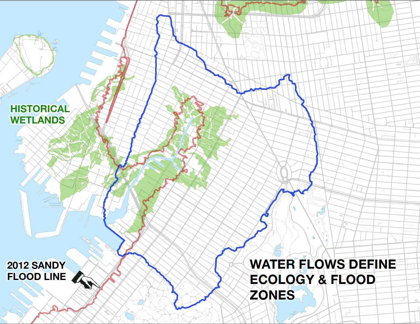
  • Jim McMahan “Map Man” who made Red Hook’s Sandy flood map will be represented by this video

  • Red Hook business owner who was here during Sandy, if we get one

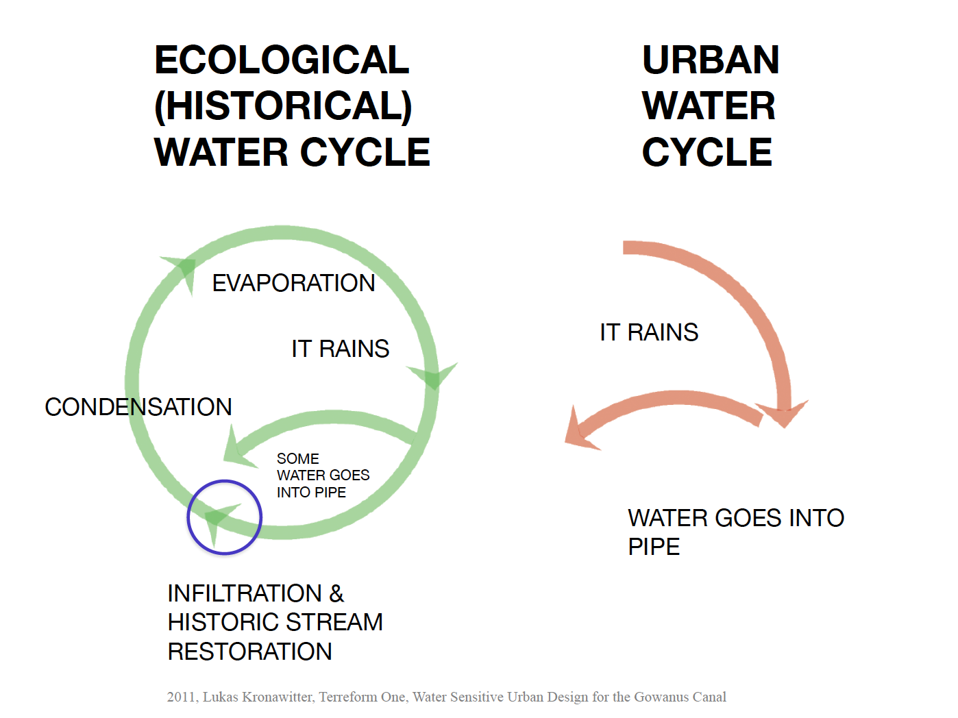
PortSide will talk about our experience protecting our ship from hurricane Sandy, what we learned about Red Hook damages while running our Sandy recovery center and then a virtual one and while appointed to NY Rising; resiliency planning we have done and that NYC government has planned and/or executed through the years since Sandy (some of it you can see within yards of our ship).  We will refer to City-executed resiliency plans for Red Hook on this webpage. We will refer to Resiliency 101 info in our virtual museum. PortSide has a FEMA Sandy recovery project, so we can speak as a storm victim too. 

Image below is the back of the postcard that will be handed out during this event, and over 2022. The front of the postcard is at top.

back of resiiency postcard portside will be distributing during 2022. frontof postcard is at top of blogpost

Unveiling of Atlantic Basin Sandy High Water Mark sign & Red Hook Sandy Flood Map

Camille Casaretti, President of the Community Education Council 15 (CEC15), stopped by to see how the sign and map could be used for educating school groups. She was greeted by PortSide Executive Director Carolina Salguero dressed as Bio Luminesence…

Camille Casaretti, President of the Community Education Council 15 (CEC15), stopped by to see how the sign and map could be used for educating school groups. She was greeted by PortSide Executive Director Carolina Salguero dressed as Bio Luminesence and PortSide Historian and Curator Peter Rothenberg.

On the 7th anniversary of hurricane Sandy, October 29, 2019, PortSide NewYork unveiled a Sandy High Water Mark sign at the pedestrian entrance to Atlantic Basin/NYC Ferry/Brooklyn Cruise Terminal in Red Hook, Brooklyn.

PortSide’s role in the creation of the Sandy High Water Mark FEMA/OEM program

Creating Sandy high water mark signs was a PortSide proposal at the White House event where we received our Champions of Change award for Sandy work. The structure of the award event was to put all the honorees on a panel and pepper us with questions to harvest ideas. The senior Federal Disaster Recovery team sought a follow-up with PortSide and come to meet us for many hours aboard the MARY WHALEN. According to Ken Curtin, the Federal Disaster Recovery Coordinator FEMA for Sandy in NY (see his video below), PortSide was the first to propose such a sign program. FEMA executed the idea and created the Sandy High Water Mark program, and NYC Emergency Management is now involved in the program.

PortSide also unveiled a banner with a map of Red Hook Sandy flooding made by a local cartographer Jim McMahon. See a copy in our e-museum here.

Carolina Salguero, Executive Director of PortSide NewYork, articulating the message from Bio Luminescence, a costume worn for Red Hook Barnacle Parade, commemorating Sandy, as well as the unveiling of a sign marking Sandy’s high watermark. The parade followed shortly after.

Assistant Commissioner Christina Farrell, NYC Emergency Management speaks. October 29, 2019.

Ken Curtin, recently retired FEMA Federal Disaster Recovery Coordinator speaking. He explained the backstory that led to the creation of the program that makes these signs, citing PortSide’s role in that story.

Carolina Salguero, Executive Director of PortSide NewYork (and Bio Luminescence for Red Hook's commemorative Barnacle Parade), speaks. October 29, 2019

PortSide NewYork's unveils a sign marking the high watermark at Red Hook's Atlantic Basin during hurricane Sandy on its seventh anniversary. Natasha Campbell, Founder of Summit Academy and PortSide NewYork board member, speaks. October 29, 2019

Unveiling the Sandy High Water Mark sign and a Sandy hurricane flood map of Red Hook by cartographer by Jim McMahon.

Dan Wiley, Congresswoman Nydia M. Velázquez's District Director of Southwest Brooklyn, speaks. October 29, 2019


Copied below

Press Release Unveiling of Atlantic Basin Sandy High Water Mark sign Red Hook Sandy Flood Map


Tues 10/29, 3:15-3:45pm

Unveiling of Atlantic Basin Sandy High Water Mark sign Red Hook Sandy Flood Map

Pedestrian gate to Atlantic Basin/NYC Ferry/Brooklyn Cruise Terminal
West end of Pioneer Street at Conover Street, Red Hook, Brooklyn, NY 11231

Followed by 4pm Barnacle Parade which musters at Pioneer and Van Brunt, one block away. 

On the 7th anniversary of hurricane Sandy, October 29, 2019, the nonprofit PortSide NewYork will unveil a Sandy High Water Mark sign at the pedestrian entrance to Atlantic Basin/NYC Ferry/Brooklyn Cruise Terminal in Red Hook, Brooklyn. This sign is an official program of FEMA and NYC Emergency Management.  Sandy’s surge was 5.75 feet high at this location. 

PortSide will also unveil a banner with a map of Red Hook Sandy flooding made by a local cartographer Jim McMahon. See a copy in our e-museum at https://redhookwaterstories.org/items/show/919.  

Immediately after the unveiling, joins us in Red Hook’s Barnacle Parade that kicks off at 4:00pm half a block up Pioneer Street and proceeds to pass the new signs. This parade is the way Red Hook memorializes Sandy since 2013 on the “Sandyversary” of 10/29.  

Carolina Salguero, Founder and Executive Director of PortSide says “After riding out hurricane Sandy on our ship to protect her from the storm, I and our Historian/Curator Peter Rothenberg came ashore to Red Hook. I was heartbroken to find the condition of our community.  I told the PortSide crew that we’re going to try and help. Our first move was to set up a pop-up aid station at Realty Collective which we ran the month of October.  PortSide has worked since that time, in many ways, to help Red Hook recover and become more resilient and to help foster resiliency for New York as a whole. Understanding the potential of our waterways is the crux of PortSide’s mission, and Sandy amplified our mission to include understanding marine weather and the destructive potential of water.  This year, PortSide’s resiliency work includes the installation of this Sandy High Water Mark sign, and next to it, the Red Hook Sandy flood map created by Jim McMahon that shows where Sandy flooded Red Hook and land elevation around our beloved but vulnerable peninsula. I hope that these signs will help educate students and adults and help them prepare for future floods.”  

The unveiling of these signs sign is another phase in PortSide’s recovery and resiliency planning work since hurricane Sandy.  PortSide received a “Champions of Change” award from the Obama White House for Sandy prevention work (protection the MARY A. WHALEN) and Sandy recovery work for Red Hook.

https://obamawhitehouse.archives.gov/champions/hurricane-sandy/carolina-salguero-(portside-newyork)

 The New York State Senate also honored PortSide for their Sandy recovery work.

https://www.nysenate.gov/legislation/resolutions/2013/j2531

PortSide founder Carolina Salguero was appointed by the Governor’s office to the NY Rising committee (the precursor to Resilient Red Hook) that created a resiliency plan for Red Hook.  For further information about Sandy and resiliency planning, visit PortSide’s e-museum Red Hook WaterStories (RHWS) www.redhookwaterstories.org  

Rep. Nydia M. Velázquez (D-NY):

“Today, seven years to the day Superstorm Sandy hit, we remember the damage our entire community endured and how we came together to help one another. This high-water mark sign sends a message that we must all continue to build community resiliency and fight climate change. I would also like to recognize PortSide NewYork’s role in Sandy recovery for which it received the White House ‘Champions of Change’ award in 2013. PortSide dreamed up a project like High Water Mark Initiative which FEMA created and NYC Emergency Management has been implementing here and around the city. This program helps alert residents and visitors alike to the dangers of storm surge and the need to be ready with a plan for the next storm. For my part, I will keep working with officials at all levels of government to promote Red Hook and our City’s resiliency and sustainability.”

New York State Senator Velmanette Montgomery says, "The Barnacle Parade represents the strength of Red Hook in the wake of super storm Sandy and serves as a reminder to all of us how climate change impacts our communities more and more each year. I am proud to represent Red Hook residents and organizations like PortSide New York who took this as a call to action and have been working tirelessly to build a more resilient community."

Councilman Carlos Menchaca says, "Red Hook’s water mark sign is a reminder of our community's resilience and how much more is needed to prepare for the next storm. The symbolic gesture must force us all to take seriously the urgency of this moment, and to do everything in our power to protect our most vulnerable neighbors from the worst effects of climate change. Thankfully, we have organizations like PortSide New York to keep us laser focused on this threat while celebrating what we've accomplished."

NYC Emergency Management Commissioner Deanne Criswell: “This High Water Mark sign is a reminder of the life-threatening risks associated with storm surge. It also highlights the strength of the Red Hook community, and serves to educate individuals about the importance of preparing for a coastal storm,” said NYC Emergency Management Commissioner Deanne Criswell.  “Through this and other initiatives, we remain dedicated to working closely with community leaders to build a culture of preparedness through stronger, more resilient neighborhoods.”

Ken Curtin, formerly of FEMA says “I was the FEMA Federal Disaster Recovery Coordinator for Sandy in NY. We came to meet the PortSide team in Red Hook since we were impressed with the recovery and resiliency ideas that they shared at the White House ceremony where they won a Sandy recovery award. Their ideas were practical, actionable and common sense, except that common sense is not so common any more. PortSide proposed that signs be installed to mark Sandy flood levels to help communities prepare for future floods. I’m glad that this program was implemented by FEMA and then adopted by NYC Emergency Management.”  

Gita Nandan, co-chair of Resilient Red Hook says, “We are thrilled about the installation of the high water mark sign. Having a physical marker in remembrance of Super Storm Sandy helps keep the memory alive of this turning point in Red Hook. As a waterfront community, Red Hook is on the forefront of climate change, and this will help keep us activated to ensure we build a resilient community for future generations.”  Resilient Red Hook is made up of concerned residents working together to steer the future of Red Hook. More at https://www.resilientredhook.org/ 

Michael Racioppo, District Manager, Brooklyn Community Board 6 says, “The high water mark high of Superstorm Sandy is something that should remind us throughout the year, not just during Halloween week, how scary the impact of climate change is.  Reminding us to be vigilant in order to maintain great waterfront, and great waterfront neighborhoods, is the continuation of the work PortSide does.”  

About PortSide NewYork www.portsidenewyork.org & www.redhookwaterstories.org
PortSide is a living lab for better urban waterways. PortSide connects New Yorkers to the benefits of our waterways and ports.  PortSide produces WaterStories programs on and off the historic ship MARY A. WHALEN in education, culture, resiliency and job training.


# # #


Red Hook flood assessment info: our watershed, sewers, buried creeks, prior shoreline & more

Amended 11/12/14 to include the following link and background about Eymund Diegel:

For related info, see our blogpost that includes Jim McMahon's Sandy flood map of Red Hook and info on how to assess your flood risk in future storms." 

More info about Eymund Diegel:

Original post:

To further support flood prevention planning in Red Hook, we offer the following information.

The data and points of view in the following bullet points are courtesy of Eymund Diegel:

  • General imagery of the Sandy Flood impacts available here
  • Base map data showing where flood waters are likely to come from next time Blue lines show general direction of drainage flows, and in reverse, the likely path of rising flood waters. Green shows the original tidal marshes. Sandy essentially flooded anyone who built on the former tidal marshes.
  • 1844 Coastal Survey showing original sand and mud banks off Red Hook whose alteration from harbor dredging is affecting how storm surges impact Red Hook
  • The reconstruction of the historic bay bottom, in particular it's now damaged and altered offshore banks, should be studied to see how reconstructing some of these protective features may help reduce Red Hook flood damage the next time.
  • I am attaching some ideas from the excellent work being done by SCAPE landscape architects, (slide show above) exploring how we remove soil from some areas (eg Red Hook Park) to recreate a better flood holding basin, and use those soils to create surge breakers further offshore. All expensive and controversial, but we need to start this dialogue as we are only going to get more flood events, and the next one will be worse than Sandy. We got off lucky because we didn't have heavy rains.
  • I did a 2013 Sandy Flood saline impacted tree survey for the Parks Department
  • The most impacted trees (London Planes and Dawn Redwoods) were typically on "topographic sinks" where salt water sat for longer, affecting soil quality and damaging non salt tolerant trees.  These "sinks" generally correspond with the location of the historic mill ponds that were landfilled and subsided.
  • The planning recommendation I made to the City is that street grading needs to be improved to allow flood waters to recede more rapidly. This recommendation will contradict some of the Brooklyn Waterfront Greenways Green Infrastructure work (eg on Columbia Street) where storm water is being diverted to pond swales and holding tanks to reduce combined sewer overflows. Both (flood management and green infrastructure sewer overflow reduction are good goals and should be supported. One compromise strategy may be sluice gates, like those used by the original millers of Red Hook to better manage tide waters.
Sandy Issues (1).jpg
Rain_Sewer_Flow.jpg
Built up to 1902.jpg

Brooklyn Greenway Stormwater Study for West Street in Greenpoint, Brooklyn includes ideas to consider

Red Hook NY Rising CRP Resiliency Open House Sat 2/22 & Sun 2/23 11am – 6pm

crp_poster_02.13.13_flattened.jpg

Red Hook NY Rising Community Reconstruction Program
Open House
Realty Collective, 351 Van Brunt St
Sat 2/22 & Sun 2/23
11am – 6pm

Where you are going:  351 Van Brunt while it was PortSide's Sandy aid center November 2012

Where you are going:  351 Van Brunt while it was PortSide's Sandy aid center November 2012

Only a few months of planning remain in the Red Hook NY Rising Community Reconstruction Program and the Committee is excited to engage the Red Hook community in the critical final phase of the program. The upcoming public meeting will be an important opportunity to gather community input on the top Priority Projects that may be recommended for funding with Red Hook’s $3M CDBG-DR allocation. We encourage everyone to attend this event and have your voice heard. At this event the Red Hook Committee will share ideas that its members have heard from you to date and answer questions you may have about the program and possible resiliency projects. Details for the event are on the attached flyer and as follows:
 
Experts will be on hand to discuss specific topics on Saturday and Sunday at the following times:
12pm-1pm: Infrastructure & Coastal Resiliency
1pm-2pm: Social Resiliency & Economic Development
 
Red Hook Resiliency Innovations event Sat 2/22, 3-6pm

Guest speakers to include: HUD Rebuild by Design, Brooklyn Greenway Initiative, Fifth Avenue Committee (FAC) and Architecture for Humanity, and others.

We also have a few newsworthy pieces from the past few months to share:

  • The Committee held its 11th meeting on Monday, February 10th in which we discussed benefits, feasibility, and considerations of possible priority resiliency projects.
  • Youth from the Red Hook Initiative/South Brooklyn Community High School film production program completed a video documenting the November 19th Public Engagement at the Miccio Center. This will be featured at the public meeting as well.
  • On December 18th, the Red Hook Planning Committee partnered with Good Shepherd’s Services at the Beacon Center to engage teens in the NY Rising program. At this event, teens brainstormed with planners and Committee representatives about resiliency challenges and solutions for Red Hook.
  • The Committee applauds the incredible news from Governor Cuomo’s Office of a $200M New York City & New York State combined commitment for the development of an integrated flood protection system in Red Hook. This announcement provides great momentum to our work and is proof that Red Hook can and will become a more resilient community.  

We hope to see everyone at the upcoming public event.
 
As always, thank you for your continued engagement in the Red Hook NY Rising Community Reconstruction Program.
 
Sincerely,
 
NY Rising Red Hook Planning Committee & Committee Co-Chairs
Gita Nandan
Ian Marvy

Like us on Facebook: https://www.facebook.com/nystormrecovery

Follow us on Twitter: https://twitter.com/NYStormRecovery

www.stormrecovery.ny.gov